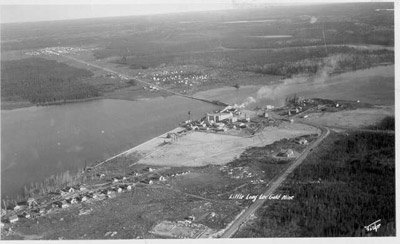
Little Long Lac Mine and Townsite (~1937)
Description
- Creator
- Harry Fisher
- Media Type
- Image
- Item Type
- Photographs
- Description
- Aerial view looking northeast across Barton Bay. Inscription reads 'Little Long Lac Gold mine'. In the foreground is the clearing for Errington Avenue. It would later be called Arena Road and in 1939, it would become part of Highway 11. At the extreme left is the townsite of Little Long Lac (known as Little Longlac). Mine Road extends left to right across the lake. In the centre is Little Long Lac Mine, and to its right, on the point, is Rosedale (Townsite). North of the bridge, finished in 1936, is Johnsonville which would later be called Jonesville. In the upper right of the photo is Geraldton, located on the railway.
- Date of Original
- ~1936-1937
- Subject(s)
- Local identifier
- GCPL: 11
- Geographic Coverage
-
-
Ontario, Canada
Latitude: 49.72667 Longitude: -86.94842
-
- Copyright Statement
- Copyright status unknown. Responsibility for determining the copyright status and any use rests exclusively with the user.
- Contact
- Greenstone Public LibraryEmail:reference@tbpl.ca
Website:
Agency street/mail address:405 Second Street West
Box 40
Geraldton, ON
P0T 1M0


