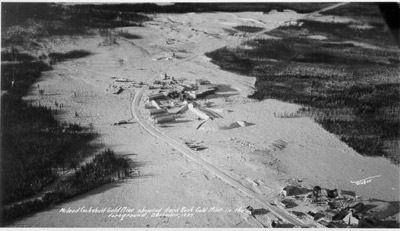
MacLeod-Cockshutt Mine (1937)
Description
- Creator
- Harry Fisher
- Media Type
- Image
- Item Type
- Photographs
- Description
- Aerial view looking northwest. Inscription reads 'MacLeod Cockshutt Gold Mine showing Hard Rock Gold mine in the foreground, December, 1937.' Upper portion shows the hills on which MacLeod Townsite is rising, and beyond it, the clearing for the Kenogamisis Golf Course. There is no sign of the future Highway 11 corridor, or of the future 'slimes', the extensive mine tailings area. Mine Road runs north towards Geraldton. THe No. 1 headframe of the MacLeod mine stands between the mine proper and the townsite. MacLeod-Cockshutt Gold Mines Ltd, was incorporated in 1933, and in the spring of 1934, the company sank No. 1 shaft. In 1936 the company sank No. 2 shaft. In May, 1938, the mine became the gold camp's 4th gold producer.
- Date of Original
- ~1937
- Subject(s)
- Local identifier
- GCPL:36
- Geographic Coverage
-
-
Ontario, Canada
Latitude: 49.72667 Longitude: -86.94842
-
- Copyright Statement
- Copyright status unknown. Responsibility for determining the copyright status and any use rests exclusively with the user.
- Contact
- Greenstone Public LibraryEmail:reference@tbpl.ca
Website:
Agency street/mail address:405 Second Street West
Box 40
Geraldton, ON
P0T 1M0


