Hardrock Mine - Discovery Point (1938)
Description
- Media Type
- Image
- Item Type
- Photographs
- Description
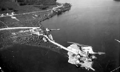
- Aerial view looking north, along the shoreline of Kenogamisis Lake. Hard Rock Gold Mine was incorporated in 1934 and in 1935 the No.1 shaft was sunk on Discovery Point. Work ceased in 1937 in order to concentrate on the No.2 shaft on Porphyry Hill, farther west(not shown). Hardrock Townsite, seen in the upper sector of this view, grew upon the lakeshore.
- Date of Original
- -1938
- Subject(s)
- Local identifier
- Library(58)
- Geographic Coverage
-
-
Ontario, Canada
Latitude: 49.72667 Longitude: -86.94842
-
- Copyright Statement
- Copyright status unknown. Responsibility for determining the copyright status and any use rests exclusively with the user.
- Contact
- Greenstone Public LibraryEmail:reference@tbpl.ca
Website:
Agency street/mail address:405 Second Street West
Box 40
Geraldton, ON
P0T 1M0