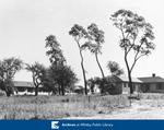
Thornton's Corners
Description
- Creator
- Peter Lofthouse, Photographer
- Media Type
- Image
- Object
- Item Type
- Negatives
- Description
- Black and white negative depicting a photograph of Thronton's Corners looking east from the residence of Peter Lofthouse. Kingston Road/Highway 2 is visible on the left side of the image as it passes through the settlement of Thronton's Corners at the intersection of Kingston Road and Thronton Road. Houses and other buildings are visible in the background. At the far left Mount Lawn Cemetery, begun in 1928, is visible.
- Notes
- This view is looking east from the residence of Peter Lofthouse which was located on the top of the hill on the south side of Kingston Road (Highway 2) at the west side of the valley where the Whitby-East Whitby border was located.
- Date of Original
- c. 1928
- Date Of Event
- c. 1928
- Dimensions
-
Width: 5 px
Height: 4 px
- Subject(s)
- Local identifier
- 28-000-048
- Collection
- Whitby Historic Photographs
- Geographic Coverage
-
-
Ontario, Canada
Latitude: 43.8912434044431 Longitude: -78.8951826095581
-
- Copyright Statement
- Public domain: Copyright has expired according to Canadian copyright law. No restrictions on use.
- Recommended Citation
- Whitby Archives
- Reproduction Notes
- Scanned from copy negative.
- Contact
- Whitby Public LibraryEmail:archives@whitbylibrary.ca
Website:
Agency street/mail address:405 Dundas Street West, Whitby, Ontario L1N 6A1
For inquires about any newspaper content please contact askreference@whitbylibrary.ca


