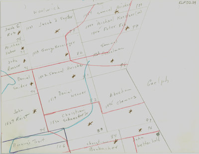
Waterloo Township map with names of early property owners
Description
- Creator
- Ellis Little, Artist
- Media Type
- Image
- Item Type
- Drawings
- Description
- Hand drawn maps of early Waterloo county with the names of property owners and approximate dates of ownership.
This map shows part of Woolwich township, the area around the settlements of Maryhill (earlier called New Germany) and Freiburg, bordering Guelph. Charles Street west and Maryhill Road on the upper right portion of the map drawn in red pencil. - Notes
- These maps are hand drawn by Ellis Little and outline over 90000 acres of land granted (Block 2, Waterloo Township) to the Six Nations Indians by the British Crown in 1784 and sold in 1798 to Richard Beasley, James Wilson and John Baptist Rousseaux who looked to resell the land in small parcels. German Company tract became Waterloo township.
Modern streets not always identified; maps are not to scale and geographic locations are approximate. Names of property owners on reverse.
See also: "Historical Atlas of Waterloo & Wellington Counties, 1877-1881"; Waterloo Historical Society 1965, pp 44-45 for 1805 Waterloo Township (German Company tract) lot map with property owner's names; and Waterloo Regional Museum website for further information.
- Dimensions
-
Width: 20 cm
Height: 25 cm
- Image Dimensions
-
Image Width: 20cm
Image Height: 25cm
- Subject(s)
- Bricker, Samuel
Erb, Peter C.
Reesor, John
German Company Tract (Waterloo, Ont.)
Eby, John
Weaver, H.
Erb, Jacob
Snider, Christian
Bricker, John
Schneider, Christian
Clemens, Abraham
New Germany (Ont.)
Maryhill (ont.)
Freiburg(Ont.)
Benninger, George
Erb, Daniel
Brohman, G.
Weaver, Daniel
Schumacher, John
Scharbach, S.
Eshelman, Samuel
Koestner, Michael
Reist, John
Brubacher, Christian
Wettenhall, John
Snider, Daniel
Huber, Michael
Erb, Jacob G.
Horning's Tract (Waterloo Township, Ont.)
Snyder, Jacob I. - Local identifier
- ELP 50 39
- Collection
- Ellis Little Papers
- Language of Item
- English
- Geographic Coverage
-
-
Latitude: 43.527144 Longitude: -80.396061
-
- Copyright Statement
- Uses other than research or private study require the permission of the rightsholder(s). Responsibility for obtaining permissions and for any use rests exclusively with the user.
- Contact
- Waterloo Public LibraryEmail:askus@wpl.ca
Website:
Agency street/mail address:35 Albert Street, Waterloo, Ontario, Canada, N2L 5E2