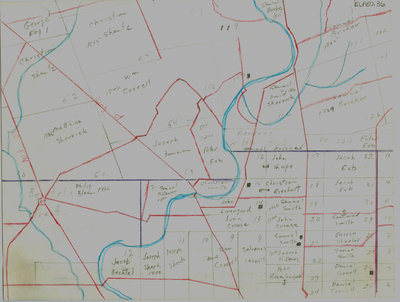
Waterloo Township map with names of early property owners
Description
- Creator
- Ellis Little, Artist
- Media Type
- Image
- Item Type
- Drawings
- Description
- Hand drawn maps of early Waterloo township with the names of property owners and approximate dates of ownership.
This map shows the early settlement of German Mills, part of Bechtel's tract in the lower left corner. German Mills was located along present day Manitou drive, south of present day Fairway road. Mill street shown on the map becomes Courtland avenue and then Fairway road. - Notes
- These maps are hand drawn by Ellis Little and outline over 90000 acres of land granted (Block 2, Waterloo Township) to the Six Nations Indians by the British Crown in 1784 and sold in 1798 to Richard Beasley, James Wilson and John Baptist Rousseaux who looked to resell the land in small parcels. German Company tract became Waterloo township.
Modern streets not always identified; maps are not to scale and geographic locations are approximate. Names of property owners on reverse.
See also: "Historical Atlas of Waterloo & Wellington Counties, 1877-1881"; and Waterloo Regional Museum website for further information. See Waterloo Historical Society journal 1965 for 1805 German Company tract/Waterloo township lot map with owners' names. - Dimensions
-
Width: 20 cm
Height: 25 cm
- Image Dimensions
-
Image Width: 20cm
Image Height: 25cm
- Subject(s)
- Bricker, Samuel
Bowman, H.
German Company Tract (Waterloo, Ont.)
Erb, John
Erb, Jacob
Bechtel's Tract (Waterloo, Ont.)
Rosenberger, Benjamin
Beasley's New Survey (Waterloo, Ont.)
Bechtel, Abraham
Bechtel, George
Snider, Christian
Cockrell, Richard
Betzner, Samuel Sr.
Cornell, Daniel
Shantz, Christian
Beasley's Middle Block (Waterloo, Ont.)
Herstand Tract (Waterloo, Ont.)
Hagey, Daniel
Lutz, Daniel
Herner, Frederick
Herstand, David
Beasley, Francis
Groh, Michael
Swartz, Chris
Reist, A. Sr.
Hilborn, Jesse
Bliehm, Philip
Cressman, Abraham
Livergood, Jacob
Wismer, Henry
Rice, John
Wildfong, Jonas
Bechtel, Joseph
Springer, Benjamin
Erb, Christian
Cornell, Salvanus
Cornell, Samuel
Rise, John
Cressman, John
Cressman, Joseph
German Mills (Waterloo, Ont.)
Beasley, Richard
Sherk, Joseph
Crouse, John
Livergood, John
Shupe, John
Riechert, Christian
Smith, Samuel
Hilborn, Joseph
Wheeler, Garret
Erb, Peter
Bowman, Joseph
Sherrick, Samuel
Sherrick, David
Eby, George
Corall, William
Correll, William
Sherrick, Matthias
Bleam, Philip - Local identifier
- ELP 50 36
- Collection
- Ellis Little Papers
- Language of Item
- English
- Geographic Coverage
-
-
Latitude: 43.408139 Longitude: -80.448827
-
- Copyright Statement
- Uses other than research or private study require the permission of the rightsholder(s). Responsibility for obtaining permissions and for any use rests exclusively with the user.
- Contact
- Waterloo Public LibraryEmail:askus@wpl.ca
Website:
Agency street/mail address:35 Albert Street, Waterloo, Ontario, Canada, N2L 5E2