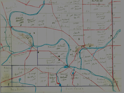
Waterloo Township map with names of early property owners
Description
- Creator
- Ellis Little, Artist
- Media Type
- Image
- Item Type
- Drawings
- Description
- Hand drawn maps of early Waterloo Township with the names of property owners and approximate dates of ownership. Red line running across middle of map from left top to right bottom is King street east. Bottom right corner is the area of Preston, upper left area is known as Doon where the Pioneer Tower Memorial Park is located.
- Notes
- These maps are hand drawn by Ellis Little and outline over 90000 acres of land granted (Block 2, Waterloo Township) to the Six Nations Indians by the British Crown in 1784 and sold in 1798 to Richard Beasley, James Wilson and John Baptist Rousseaux who looked to resell the land in small parcels. German Company tract became Waterloo township.
Maps are not to scale and geographic location is approximate.
See also: "Historical Atlas of Waterloo & Wellington Counties, 1877-1881"; Waterloo Regional Museum website; Waterloo Historical Society 1965, pp 44-45 for 1805 Waterloo Township (German Company tract) lot map with property owner's names - Dimensions
-
Width: 20 cm
Height: 25 cm
- Image Dimensions
-
Image Width: 20cm
Image Height: 25cm
- Subject(s)
- Bean, John
Bricker, Samuel
Wilson, James
German Company Tract (Waterloo, Ont.)
Erb, John
Erb, Jacob
Bechtel, Jacob
Bechtel's Tract (Waterloo, Ont.)
Bean's Tract (Waterloo, Ont.)
Rosenberger, Benjamin
Bean, Abraham
Hamacher, Peter
Stegman, David
Bechtel, Abraham
Bechtel, George
Snider, Christian
Staeffer, A.
Beasley's Old Survey
Cockrell, Richard
Ryckman, Samuel
Dodge, Nathaniel
Preston, Benham
Betzner, Samuel Sr.
Betzner, Samuel, Jr.
Cornell, Daniel
Peck, Lynus
Keagie, John
Bowman, Joshua
Wismer, Joseph
Saltzberry, Philip
Bricker, John
Betzner, Samuel Jr.
Sararus, Andrew
Shantz, Christian
Barman, Joseph
Groh, Michael
Livergood, Jacob
Bechtel, Joseph
Cornell, Salvanus
Cornell, Samuel
Beasley, Richard
Sherk, Joseph
Smith, Samuel
Hilborn, Joseph
Wheeler, Garret
Preston (Ont.)
Cornell, Sylvanus
Rosenberger, Jacob - Local identifier
- ELP 50 35
- Collection
- Ellis Little Papers
- Language of Item
- English
- Geographic Coverage
-
-
Latitude: 43.400682 Longitude: -80.402584
-
- Copyright Statement
- Uses other than research or private study require the permission of the rightsholder(s). Responsibility for obtaining permissions and for any use rests exclusively with the user.
- Contact
- Waterloo Public LibraryEmail:askus@wpl.ca
Website:
Agency street/mail address:35 Albert Street, Waterloo, Ontario, Canada, N2L 5E2