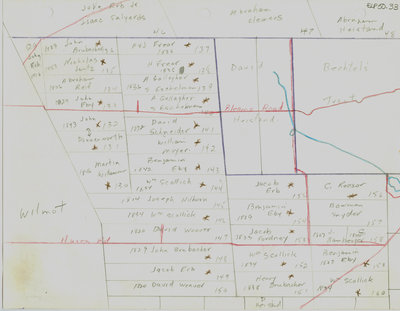
Waterloo Township map with names of early property owners
Description
- Creator
- Ellis Little, Artist
- Media Type
- Image
- Item Type
- Drawings
- Description
- Hand drawn maps of early Waterloo township with the names of property owners and approximate dates of ownership. This map shows an area between Bleams Road and Huron Road between Fisher-Hallman and Trussler roads.
- Notes
- These maps are hand drawn by Ellis Little and outline over 90000 acres of land granted (Block 2, Waterloo Township) to the Six Nations Indians by the British Crown in 1784 and sold in 1798 to Richard Beasley, James Wilson and John Baptist Rousseaux who looked to resell the land in small parcels. German Company tract became Waterloo township.
Maps are not to scale and geographic locations are approximate.
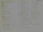
Names of property owners on reverse.
See also: "Historical Atlas of Waterloo & Wellington Counties, 1877-1881"; Waterloo Regional Museum website; Waterloo Historical society journal 1965 for 1805 Waterloo township/German Company tract lot map with owners' names. - Subject(s)
- Bricker, Samuel
Brubacher, John E.
Erb, Abraham
Bricker, Jacob
Brubacher Family
Schneider, David
Moyer, William
German Company Tract (Waterloo, Ont.)
Erb, John
Yund, J.
Wideman, Martin
Erb, D.
Erb, P.
Donnenworth, Jacob
Eby, C.
Eby, John
Wissler, Jacob
Reif, Abraham
Jantz, Nicholas
Frear, H.
Gallagher, A.
Eschelman, S.
Hershey, J.
Eby, Benjamin
Scollick, William
Hillborn, Joseph
Erb, James
Weaver, David
Weaver, H.
Erb, Jacob
Huber, Christian
Cressman, Hilgartner
Brubacher, Henry
Fordney, Jacob
Holl, Peter
Reesor, P.
Reesor, C.
Bamberger, P.
Bamberger, C.
Bamberger, S.
Eby, James
Heistand, David
Bechtel, Jacob
Bechtel Tract (Waterloo, Ont.)
Bechtel's Tract (Waterloo, Ont.)
Beasley, Richard
Donnenworth, John
Frear, J. - Local identifier
- ELP50.33
- Collection
- Ellis Little Papers
- Geographic Coverage
-
-
Latitude: 43.397065 Longitude: -80.512104
-
- Copyright Statement
- Uses other than research or private study require the permission of the rightsholder(s). Responsibility for obtaining permissions and for any use rests exclusively with the user.
- Contact
- Waterloo Public LibraryEmail:askus@wpl.ca
Website:
Agency street/mail address:35 Albert Street, Waterloo, Ontario, Canada, N2L 5E2