Bridge over Twenty Mile Creek
Description
- Creator
- Kenneth Moyer, Photographer
- Media Type
- Image
- Item Type
- Photographs
- Description
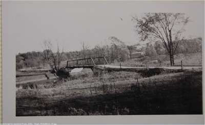
- A view, looking south east, of the bridge over Twenty Mile Creek.
- Notes
- The area on the right is currently used as a commercial camp ground.
This bridge was replaced in the 1960s with an army surplus bridge (called a Bailey Bridge). - Date of Original
- 1950
- Subject(s)
- Geographic Coverage
-
-
Ontario, Canada
Latitude: 43.1519431453908 Longitude: -79.3744611740112
-
- Copyright Statement
- Copyright status unknown. Responsibility for determining the copyright status and any use rests exclusively with the user.
- Contact
- Lincoln Pelham Public LibraryEmail:admin@lppl.ca
Website:
Agency street/mail address:4080 John Charles Blvd.,
Vineland, Ontario L0R 2C0