Results


Page 2 of 3
- This is the C.N.R. rail yard in Rainy River as it appeared in 1935. It is quite a contrast from the current operation. Today the yards handle tonnage far in excess of what was handled during the 'steThis is the C.N.R. rail yard in Rainy River as it appeared …
- A view of the Canadian National Railway yards as it appeared in 1935, looking east in Rainy River, Ontario. This is quite a contrast from today's local operation which handles tonnage far in excess oA view of the Canadian National Railway yards as it appeared in …
- Aerial view of Rainy River showing its importance as a major lumbering center as early as 1900. Rainy River was the mid point transfer for shipment of grain from the west and lumber to the east, forAerial view of Rainy River showing its importance as a major lumbering …
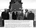
- On September 3,1973, a historical plaque commemorating the Canadian Northern Railway was unveiled at Rainy River. Shown from left to right-John Sirman (C.N.R. Rainy River), Arthur Solomomian,(Clerk-TOn September 3,1973, a historical plaque commemorating the Canadian Northern Railway was …
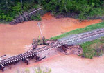
- In this photo we see the damage to C.N.R. tracks, hydro lines and culverts that resulted after the heavy rainfall in June 2002. This aerial photo was taken two miles from Flanders Station near RainyIn this photo we see the damage to C.N.R. tracks, hydro lines …
- Aerial shot of flood damage caused near Flanders Station in Ontario.Aerial shot of flood damage caused near Flanders Station in Ontario.
- Aerial view of the washout of the tracks on the Seine River near Flanders Station, Ontario.Aerial view of the washout of the tracks on the Seine River …
- Coloured photo of the rise in river flow after the flood in June 2002, Rainy River Ontario.Coloured photo of the rise in river flow after the flood in …
- An aerial view of the damage to the C.N.R. tracks over the Seine River, June 2002. This aerial photo of the Seine River, was taken two miles from Flanders Station.An aerial view of the damage to the C.N.R. tracks over the …
- Damage to the railroad tracks was caused by heavy rainfall in the area of Rainy River-Fort Frances.Damage to the railroad tracks was caused by heavy rainfall in the …
- Aerial view of the damage to C.N.R tracks over the Seine River after a heavy rainfall. Photo was taken on June 11, 2002.Aerial view of the damage to C.N.R tracks over the Seine River …
- Coloured aerial photo of C.N.R. train tracks buried in erosion caused by the heavy rainfalls that occurred in this Northwestern region during the month of June 2002.Coloured aerial photo of C.N.R. train tracks buried in erosion caused by …
- Aerial view of damage to C.N.R. tracks submerged by tree boughs and debris from overflow of the river.Aerial view of damage to C.N.R. tracks submerged by tree boughs and …
- The gentlemen that wore these hats were conductors for the railroad. In this position, they were the most visible of the railway men. They were responsible for assisting the public traveling on the tThe gentlemen that wore these hats were conductors for the railroad. In …
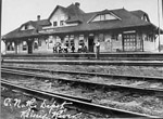
- An earlier glimpse of the C.N.R. depot in Rainy River. Rainy River was the division point between Thunder Bay and Winnipeg. The dimensions of the 129'x30' depot is unique as it has the absence of a bAn earlier glimpse of the C.N.R. depot in Rainy River. Rainy River …
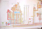
- The above chart is a diagram of the braking system used on the Santa Fe 4008.The above chart is a diagram of the braking system used on …
- Aerial, coloured photo showing the washout of railway track near Rainy River, Ontario. This photo was taken around Mine Centre, Ontario.Aerial, coloured photo showing the washout of railway track near Rainy River, …
- Another aerial view of the damage to the railway tracks near Mine Centre, Ontario. Heavy rains in the area caused major flooding in June, 2002.Another aerial view of the damage to the railway tracks near Mine …
- Aerial view of the damage beside the bailey bridge, on the Price River. Damage is from the rains that caused the flooding of the Rainy River area, June, 2002.Aerial view of the damage beside the bailey bridge, on the Price …
- An aerial view of the washout from the extensive rains that caused the flooding of the Rainy River area in June of 2002. This view is approximately 135 miles west of Rainy River.An aerial view of the washout from the extensive rains that caused …
Page 2 of 3


