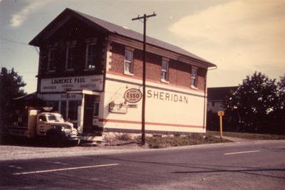
Sheridan General Store, Circa 1950.
Description
- Media Type
- Image
- Item Type
- Photographs
- Description
- The Sheridan "Four Corners" intersection was Upper Middle Road and the Town Line between Trafalgar and Halton Townships, which is now Winston Churchill Blvd. (The Queen Elizabeth Way Highway altered Upper Middle Road when it was curved south going west from Mississauga into Oakville.) Early settlement in the area was slow; in 1812, there were only about 28 families between the Credit River and Burlington, south of Dundas Highway (also known then as "the Military Road"). The Greeniaus Red School House was at the intersection of what is now Southdown Road and Truscott Road by 1826. There was a school/community hall on the south-west side of what is now Winston Churchill Blvd. and the South Service Road. The Hardy School was on Ninth Line, south of Upper Middle Road. In these early days, the village was called "Hammondville".
The general store was opened in 1857, built by Erasmus Hill who also had a carpenter's shop there for building chairs and furniture. William Kelly, who had been born on his parent's farm just east along what is now Truscott Road, just west of today's Park Royal Plaza, was an early owner of the general store. William Ryerson was another who had the store. The store owner at the time of this photograph, Lawrence Paul, built a new store on the northwest side of the North Service Road after the highway dismantled the village. He had purchased the store in about 1945 from J. E. Sinclair.
First the community hall, then the church and the general store, post office, the blacksmith shop, T. Wainwright's tannery and John Long's carpenter and wagon making shop and in later years, the gas pumps, brought Sheridan people from quite a large area in all directions to the "Four Corners". The coming of the railway had quite an impact on area farmers as it brought easy access to Toronto but it was the building of the QEW to speed traffic between the border and Toronto one hundred years later in the mid-1950's that ended Sheridan. Now all that remains of the vanished village centre is a cairn and silo on the south-west side of the Queen Elizabeth Highway at Winston Churchill Boulevard in Mississauga. - Notes
- In 1857, the village name was changed from Hammondville to Sheridan in honour of the Irish playwright, Richard Brinsley Sheridan.
Information is taken from "Thy Humble Dwelling: a History of Sheridan-Park Royal United Church 1826 - 1992", edited by the Rev. Robert K. Munro, and, Heritage Mississauga's website, "The Lost Villages" linked here as well as the Oakville Journal's March 29, 1954 article, "Have All Sheridan Property Needed for Roads Says Elson". - Inscriptions
- On side of building: Sheridan.
On end of building: Lawrence Paul, can't read the rest.
Sign on hydro pole: Imperial Esso Gasoline - Subject(s)
- Local identifier
- TTOILMR0054
- Collection
- Trafalgar Township Historical Society
- Language of Item
- English
- Geographic Coverage
-
-
Ontario, Canada
Latitude: 43.50011 Longitude: -79.78293
-
- Copyright Statement
- Copyright status unknown. Responsibility for determining the copyright status and any use rests exclusively with the user.
- Recommended Citation
- Sheridan General Store, Circa 1950.
- Contact
-
Trafalgar Township Historical Society Sponsor: Jeff Knoll, Local & Regional Councillor for Oakville Ward 5 – Town of Oakville/Regional Municipality of Halton