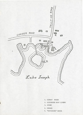
Hand drawn Map of the Summit House, Ditchburn Boat Livery, and the "Nipissing" Wreck.
Description
- Creator
- Various, Illustrator
- Media Type
- Image
- Text
- Item Types
- Maps
- Postcards
- Description
- Hand drawn map of where the Summit House, Ditchburn Boat Livery, Store, Chruch and the "Nipissing" Wreck.
- Notes
- Conger Road, Tally-ho Road, Lake Joseph, 1. Summit House, 2.Ditchburn Boat Livery, 3. Store, 4. Church, 5. "Nipissing" Wreck
- Dimensions
-
Width: 27.8 cm
Height: 20 cm
- Image Dimensions
-
Image Width: 27.8cm
Image Height: 20cm
- Subject(s)
- Local identifier
- Blue Album
- Language of Item
- English
- Copyright Statement
- Protected by copyright: Uses other than research or private study require the permission of the rightsholder(s). Responsibility for obtaining permissions and for any use rests exclusively with the user.
- Copyright Date
- 1985
- Copyright Holder
- Seguin Public Libraries
- Copyright Holder Contact Information
- Humphrey Library, 15 Humphrey Drive, RR#2, Parry Sound, Ontario P2A2W8, humphreylibrary@cogeco.net , 705 732 4526
- Contact
- Seguin Public LibraryEmail:pgwynne13@gmail.com
Website:
Agency street/mail address:15 Humphrey Drive, R.R. #2
Humphrey, ON P2A 2W8
(705) 732-4526


