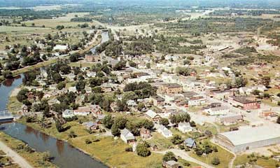
Aerial Shot of Thessalon, circa 1950
Description
- Media Type
- Image
- Item Types
- Photographs
- Aerial photographs
- Description
- This is a colour photo of an aerial view of Thessalon showing a summer view of the eastern half of the Town. Some of the recognizable landmarks are the Thessalon Arena in the lower right, St. Ambrose Catholic Church on the west side of the river (middle of the photo), and Highway 17 running east and west toward the top of the photo. The Thessalon River can be seen in the left portion of the photograph.
- Date of Original
- Circa 1950
- Subject(s)
- Collection
- Local History
- Language of Item
- English
- Geographic Coverage
-
-
Ontario, Canada
Latitude: 46.25006 Longitude: -83.5666
-
- Creative Commons licence
 [more details]
- Copyright Statement
- Public domain: Copyright has expired according to Canadian law. No restrictions on use.
- Contact
- Thessalon Union Public LibraryEmail:thessalonlib@thessalonlibrary.ca
Website:
Agency street/mail address:187 Main St. Box 549
Thessalon, ON P0R 1L0


