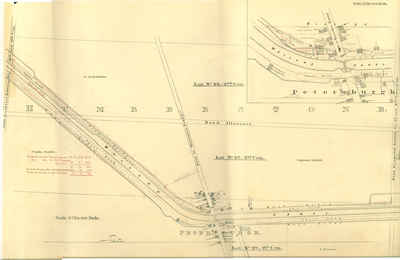
Second Welland Canal - Book 3, Survey Map 19 - Petersburgh and Humberstone
Description
- Creator
- Welland Canal Company
- Media Type
- Image
- Item Type
- Drawings
- Description
- Survey map of the Second Welland Canal created by the Welland Canal Company showing the areas in and around Petersburg and Humberstone.
Identified structures associated with the Canal include North and South Back Ditches, Bridge Tender's Building, Towing Path, Old Back Ditch, and Covered Drain.
Features of the First Welland Canal are noted in red ink.
Surveyor measurements and notes can be seen in red and black ink and pencil.
Local area landmarks include bridge, barns, ruins of Stone Mill (burnt), Wesbern (Wabern) Hotel and spoil banks.
Roads labelled running parallel to Canal is the south Road Allowance. Roads perpendicular to Canal include Road Allowance between 1st and 2nd Concession, Road to Waterloo Ferry, Road Allowance between 2nd and 3rd Concessions.
Properties and property owners/renters are identified as follows: A. Augustine, Captain Duffil, O. Farres, I. Schooley, George Augustine, E. Schooley (Schooly), R. & J. Kilmer (Killmer), J. Urich, J. Thompson (Tompson), M. Reeb, G. Wilson, J. Klee, John Steel, E. Augustine, Furry, J. Jackson, Robert House, R. White, J. Crame, D. Saff, J. Kinnard, J. Schooley, Dickson, C. Erhoff, and G. Rother. - Inscriptions
- "Village of Petersburgh" - Scale 2 Chs. per Inch
"Humberstone" - Scale 4 Chs. per Inch,
- Publisher
- Welland Canal Company
- Date of Original
- c.1845
- Dimensions
-
Width: 100 cm
Height: 45 cm
- Image Dimensions
-
Image Width: 85cm
Image Height: 45cm
- Map Scale
- 2 Chains per Inch
- Subject(s)
- Local identifier
- WCM-BK3-Map19
- Collection
- St. Lawrence Seaway Authority (Canada) Fonds
- Language of Item
- English
- Geographic Coverage
-
-
Ontario, Canada
Latitude: 42.901622 Longitude: -79.247732
-
- Copyright Statement
- Protected by copyright: Uses other than research or private study require the permission of the rightsholder(s). Responsibility for obtaining permissions and for any use rests exclusively with the user.
- Copyright Holder
- © St. Lawrence Seaway Authority (Canada). © Transport Canada.
- Copyright Holder Contact Information
- Copyright Bureau, Services Branch
Library and Archives Canada
395 Wellington Street, Ottawa K1A 0N4
Tel.: 613-996-7502 / Fax: 613-996-1341
Email: copyright/droit_d’auteur@lac-bac.gc.ca
- Recommended Citation
- Brock University Archives, St. Lawrence Seaway Authority (Canada) Fonds, Second Welland Canal Survey Map 1, c.1845.
- Terms of Use
- This record is Crown copyrighted. Permission to reproduce this record must be granted by Library and Archives Canada.
- Reproduction Notes
- © St. Lawrence Seaway Authority (Canada). Reproduced with the permission of the Minister of Public Works and Government Services Canada (2006).
Source: Library and Archives Canada/St. Lawrence Seaway Authority fonds/R1195-0-X-E/Accession 73-27727 CA
© Transport Canada. Reproduced with the permission of the Minister of Public Works and Government Services Canada (2006).
Source: Library and Archives Canada/Department of Railways and Canals fonds/R610-154-8-E/Accession 9017 CA
- Contact
- Brock University ArchivesEmail:dsharron@brocku.ca
Website:
Agency street/mail address:James A. Gibson Library,
Brock University,
500 Glenridge Avenue,
St. Catharines, Ontario L2S 3A1
Telephone: 905-688-5550 x3264