Second Welland Canal - Book 2, Survey Map 14 - Lock 26 and Allanburgh
Description
- Creator
- Welland Canal Company
- Media Type
- Image
- Item Type
- Drawings
- Description
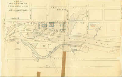
- Survey map of the Second Welland Canal created by the Welland Canal Company showing the canal as it passes through the Village of Allanburgh. Identified structures and features associated with the Canal include Lock 26, a Guard Lock, Lock Tender's House, the New Cut, waste wear, and the towing path.
Parts of the old canal are indentified and include Old Lock 36 and 37, and the Old Cut.
The surveyors' measurements and notes can be seen in red and black ink and pencil.
Local area landmarks are also identified and include streets and roads (ex. Holland Road, Centre Street, Falls Street, Canal Street, and Clifton Street), Allanburgh Hotel, Rannies Store, Wright & Duncan Grist Mill, A. Vanderburgh Saw Mill, W. Pennock Shingle Factory, John Harper Tavern, a very delapitated Grist and Saw Mill, store house, a shanty, and a number of other structures - some of which are identified by their owners: A. Vanderburgh, W. Wright, C. Brent, and H. Mussen.
Properties and property owners of note are: Lots 118 and 119, Captain Creighton, and William H. Merritt Jr. A number of small properties labeled 1 through 39 are present and of these 6 - 15 are reserved for a Mill Site and are outlined in red. Several other pieces of land are outlined in blue and belong to: W. B. Hendershot, P. Finlay, W. Wright, and L. Leslie. There is also a piece of land reserved for hydraulic purposes. - Publisher
- Welland Canal Company
- Date of Original
- c.1868
- Dimensions
-
Width: 100 cm
Height: 45 cm
- Image Dimensions
-
Image Width: 85cm
Image Height: 45cm
- Map Scale
- 2 Chs. per inch
- Subject(s)
- Local identifier
- WCM-BK2-Map14
- Collection
- St. Lawrence Seaway Authority (Canada) Fonds
- Geographic Coverage
-
-
Ontario, Canada
Latitude: 43.077885 Longitude: -79.210675
-
- Copyright Statement
- Protected by copyright: Uses other than research or private study require the permission of the rightsholder(s). Responsibility for obtaining permissions and for any use rests exclusively with the user.
- Copyright Holder
- © St. Lawrence Seaway Authority (Canada). © Transport Canada.
- Copyright Holder Contact Information
- Copyright Bureau, Services Branch
Library and Archives Canada
395 Wellington Street, Ottawa K1A 0N4
Tel.: 613-996-7502 / Fax: 613-996-1341
Email: copyright/droit_d’auteur@lac-bac.gc.ca
- Recommended Citation
- Brock University Archives, St. Lawrence Seaway Authority (Canada) Fonds, Second Welland Canal Survey Map 1, c.1845.
- Terms of Use
- This record is Crown copyrighted. Permission to reproduce this record must be granted by Library and Archives Canada.
- Reproduction Notes
- © St. Lawrence Seaway Authority (Canada). Reproduced with the permission of the Minister of Public Works and Government Services Canada (2006).
Source: Library and Archives Canada/St. Lawrence Seaway Authority fonds/R1195-0-X-E/Accession 73-27727 CA
© Transport Canada. Reproduced with the permission of the Minister of Public Works and Government Services Canada (2006).
Source: Library and Archives Canada/Department of Railways and Canals fonds/R610-154-8-E/Accession 9017 CA
- Contact
- Brock University ArchivesEmail:dsharron@brocku.ca
Website:
Agency street/mail address:James A. Gibson Library,
Brock University,
500 Glenridge Avenue,
St. Catharines, Ontario L2S 3A1
Telephone: 905-688-5550 x3264


