Results
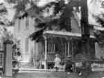
- This brick house was built for W.H. Clendenan, about 1875, on the north side of Dundas Street, east of Wellington Street (at 734 Dundas Street West). It became the Spruce Villa Hotel about 1920 and wThis brick house was built for W.H. Clendenan, about 1875, on the …
- Whitby’s house numbering system was provided by Rev. Dr. James Roy Van Wyck (1877-1941), a retired Presbyterian minister. Van Wyck provided this service to the town, free of charge, during the GreatWhitby’s house numbering system was provided by Rev. Dr. James Roy Van …
- This brick Regency Cottage was built about 1855 at the south-east corner of Dunlop and King Streets (at 319 Dunlop street West). This picture was taken after a new porch was put on the house, this saThis brick Regency Cottage was built about 1855 at the south-east corner …
- Whitby’s house numbering system was provided by Rev. Dr. James Roy Van Wyck (1877-1941), a retired Presbyterian minister. Van Wyck provided this service to the town, free of charge, during the GreatWhitby’s house numbering system was provided by Rev. Dr. James Roy Van …
- The Joshua Richardson house was built at the north-east corner of Dundas Street and Garden Street (at 720 Dundas Street East) and was demolished in 169 after several fires were set in it. In the 1920The Joshua Richardson house was built at the north-east corner of Dundas …
- This house was located on the west side of Henry Street, north of Victoria Street where Iroquois Park is now located. This residence was demolished many years ago. Whitby’s house numbering system wasThis house was located on the west side of Henry Street, north …
- This house was built in the 1850s and demolished in 1982. It was located at 120 Ash Street.Whitby’s house numbering system was provided by Rev. Dr. James Roy Van Wyck (1877-1941), a retired PresbyterThis house was built in the 1850s and demolished in 1982. It …
- John Thomas was Whitby's Night Watchman from 1921 to 1950. This house was located at 402 Byron Street South. Whitby’s house numbering system was provided by Rev. Dr. James Roy Van Wyck (1877-1941), aJohn Thomas was Whitby's Night Watchman from 1921 to 1950. This house …
- This brick house at the north-west corner of Dundas and Pine Streets (at 416 Dundas Street East) was built in 1907 and demolished in 1977. Mr. and Mrs. Charles McClellan and several relatives are staThis brick house at the north-west corner of Dundas and Pine Streets …
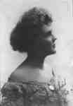
- Vida Irene Perrin was born at Newcastle, Ontario on September 25, 1882, and in the early 1900s, lived in Whitby. She was a daughter of John H. Perrin, owner of the Royal Hotel from about 1910 to 1923Vida Irene Perrin was born at Newcastle, Ontario on September 25, 1882, …
- Reverend David Marshall was born at Perthshire, Scotland on July 1, 1890. He studied for the ministry at the University of Glasgow and served with the Royal Army Medical Corps in Belgium and France dReverend David Marshall was born at Perthshire, Scotland on July 1, 1890. …
- Reverend David Marshall was born at Perthshire, Scotland on July 1, 1890. He studied for the ministry at the University of Glasgow and served with the Royal Army Medical Corps in Belgium and France dReverend David Marshall was born at Perthshire, Scotland on July 1, 1890. …
- Grass Park is located at 41 Baldwin Street. It is a triangle shaped piece of land bounded by Roebuck Street, Baldwin Street and Mill Street (Cassels Road). This view is looking west from the intersecGrass Park is located at 41 Baldwin Street. It is a triangle …
- Jephsons Hardware store was located at the northeast corner of Baldwin and Roebuck Streets.Jephsons Hardware store was located at the northeast corner of Baldwin and …
- This picture was taken from the Public and Continuation School on the south east corner of Highway 12 and Winchester Road. The United Church was located at the south-east corner of Mill Street (CasseThis picture was taken from the Public and Continuation School on the …
- The Brooklin Public and Continuation School was located on Baldwin Street. It was built in 1923 on the south east corner of Highway 12 and Winchester Road. It was officially opened on January 30, 192The Brooklin Public and Continuation School was located on Baldwin Street. It …
- Whitby’s house numbering system was provided by Rev. Dr. James Roy Van Wyck (1877-1941), a retired Presbyterian minister. Van Wyck provided this service to the town, free of charge, during the GreatWhitby’s house numbering system was provided by Rev. Dr. James Roy Van …
- Brooklin Methodist Church was located at 19 Cassels Road East. It was built in 1867 on the south-east corner of Mill Street (Cassels Road) and Princess Street. In 1925 it became the Brooklin United CBrooklin Methodist Church was located at 19 Cassels Road East. It was …
- Brooklin Methodist Church was located at 19 Cassels Road East. It was built in 1867 on the south-east corner of Mill Street (Cassels Road) and Princess Street. In 1925 it became the Brooklin United CBrooklin Methodist Church was located at 19 Cassels Road East. It was …
- This church was located at 45 Cassels Road East at the south west corner of Cassels Road and Church Street. It was built as a Bible Christian Church in 1876. From 1884 to 1916 it was a Baptist ChurchThis church was located at 45 Cassels Road East at the south …


