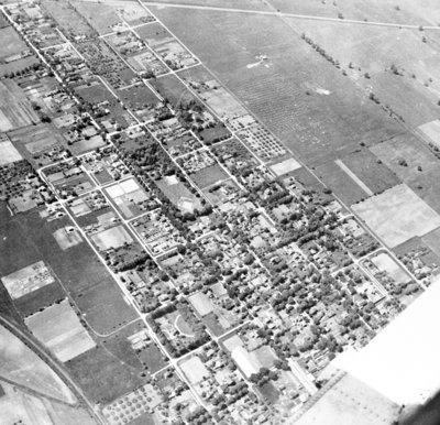
South Whitby Aerial View, 1938
Description
- Creator
- G. Norman Irwin, Photographer
- Media Type
- Image
- Item Types
- Negatives
- Photographs
- Description
- Black and white negative of an aerial photograph showing the south portion of Whitby from Gilbert Street south to the Canadian National Railway.
- Notes
- This photograph was taken to show the proposed route of Highway 401 which would follow the railway line.
- Date of Original
- June 1938
- Dimensions
-
Width: 7 cm
Height: 7.5 cm
- Subject(s)
- Local identifier
- 22-000-031
- Collection
- Whitby Online Historic Photographs Collection
- Geographic Coverage
-
-
Ontario, Canada
Latitude: 43.8798301571018 Longitude: -78.9422607421875
-
- Creative Commons licence
 [more details]
- Copyright Statement
- Public domain: Copyright has expired according to Canadian copyright law. No restrictions on use.
- Recommended Citation
- South Whitby Aerial View, 1938, G. Norman Irwin, Whitby Archives, 22-000-031.
- Reproduction Notes
- Scanned from copy negative.
- Contact
- Whitby Public LibraryEmail:archives@whitbylibrary.ca
Website:
Agency street/mail address:405 Dundas Street West, Whitby, Ontario L1N 6A1
For inquires about any newspaper content please contact askreference@whitbylibrary.ca

