Barns at Mark Crawforth Farm
Description
- Creator
- Unknown
- Media Type
- Image
- Object
- Item Type
- Negatives
- Description
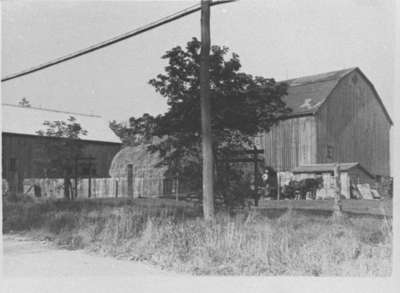
- Black and white negative depicting a photograph of the barns at the farm of Mark Crawforth. There is a tree and pole at centre of photograph but the sides of two barns can be seen. The man with horses at the right is Albert Joshua Crawforth.
- Notes
- These barns were located on the north side of the Base Line and were demolished in 1939 to build Highway 401. The farm was located on lot 20 of Concession 1, Base Line.
- Date of Original
- c.1939
- Date Of Event
- c.1939
- Dimensions
-
Width: 3.5 cm
Height: 2.5 cm
- Subject(s)
- Local identifier
- 28-000-130
- Collection
- Whitby Historic Photographs
- Geographic Coverage
-
-
Ontario, Canada
Latitude: 43.8706732344526 Longitude: -78.8962554931641
-
- Copyright Statement
- Public domain: Copyright has expired according to Canadian copyright law. No restrictions on use.
- Recommended Citation
- Whitby Archives
- Reproduction Notes
- Scanned from copy negative.
- Contact
- Whitby Public LibraryEmail:archives@whitbylibrary.ca
Website:
Agency street/mail address:405 Dundas Street West, Whitby, Ontario L1N 6A1
For inquires about any newspaper content please contact askreference@whitbylibrary.ca
