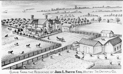
Residence of John L. Smith
- Publication
- Illustrated Historical Atlas of the County of Ontario, Ont. (Toronto, Ontario), 1877, P.# 54
Description
- Creator
- Unknown
- Media Type
- Image
- Object
- Item Types
- Negatives
- Photographs
- Description
- Black and white negative depicting a sketch of the residence and farm of John L. Smith from the Illustrated Historical Atlas of the County of Ontario. The farm was also called Curvis Farm.
- Notes
- This brick farmhouse was located on lot 21 of Broken Front Concession on the west side of Thickson Road. It was north of the stone house owned by Thomas H. Smith. The John L. Smith house was destroyed by fire on 2 November 1974.
- Inscriptions
- 'Curvis Farm the Residence of John L. Smith ESQ. Whitby Tp. Ontario Co.' printed underneath the image.
- Publisher
- J.H. Beers & Co.
- Place of Publication
- Toronto
- Date of Original
- 1877
- Date Of Event
- 1877
- Dimensions
-
Width: 6.5 cm
Height: 6.5 cm
- Image Dimensions
-
Image Width: 28cm
Image Height: 16.9cm
- Subject(s)
- Local identifier
- 28-000-035
- Collection
- Whitby Historic Photographs
- Language of Item
- English
- Geographic Coverage
-
-
Ontario, Canada
Latitude: 43.88342 Longitude: -78.93287
-
- Copyright Statement
- Public domain: Copyright has expired according to Canadian copyright law. No restrictions on use.
- Recommended Citation
- Whitby Archives
- Reproduction Notes
- Scanned from copy negative.
- Contact
- Whitby Public LibraryEmail:archives@whitbylibrary.ca
Website:
Agency street/mail address:405 Dundas Street West, Whitby, Ontario L1N 6A1
For inquires about any newspaper content please contact askreference@whitbylibrary.ca

