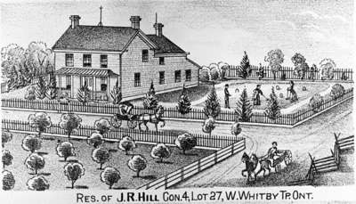
Residence of John R. Hill
- Publication
- Illustrated Historical Atlas of the County of Ontario, Ont. (Toronto, Ontario), 1977
Description
- Creator
- Unknown
- Media Type
- Image
- Object
- Item Types
- Photographs
- Negatives
- Description
- Black and white negative depicting an print of the residence and farm of John R. Hill from the Illustrated Historical Atlas of the County of Ontario.
- Notes
- John R. Hill lived on the north half of lot 27 of Concession 4 (Taunton Road) in Whitby Township.
- Inscriptions
- 'Res. John R. Hill Con.4, Lot 27, W. Whitby Tp., Ont.' printed underneath the image. This wooden home was bricked over in 1910.
- Publisher
- J.H. Beers & Co.
- Place of Publication
- Toronto
- Date of Original
- 1977
- Date Of Event
- 1877
- Dimensions
-
Width: 6.5 cm
Height: 6.5 cm
- Image Dimensions
-
Image Width: 28cm
Image Height: 16cm
- Subject(s)
- Local identifier
- 28-000-032
- Collection
- Whitby Historic Photographs
- Geographic Coverage
-
-
Ontario, Canada
Latitude: 43.88342 Longitude: -78.93287
-
- Copyright Statement
- Public domain: Copyright has expired according to Canadian copyright law. No restrictions on use.
- Recommended Citation
- Whitby Archives
- Reproduction Notes
- Scanned from copy negative.
- Contact
- Whitby Public LibraryEmail:archives@whitbylibrary.ca
Website:
Agency street/mail address:405 Dundas Street West, Whitby, Ontario L1N 6A1
For inquires about any newspaper content please contact askreference@whitbylibrary.ca
