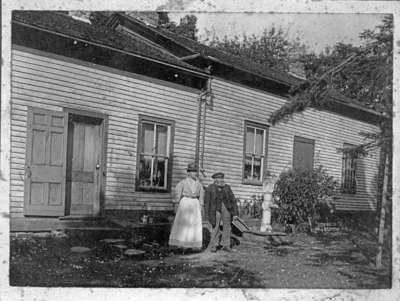
Thomas Manderson Residence
Description
- Creator
- Unknown
- Media Type
- Image
- Object
- Item Type
- Negatives
- Description
- Black and white negative depicting a photograph of the residence of Thomas Manderson. Sarah Manderson (1848-1920)and her brother, Thomas Manderson (1836-1921), stand in front of the house in the foreground. There is a water pump on the right side of the image.
- Notes
- This frame house was built by the Manderson family on lot 11 of Concession 1 on the north-west corner of Highway 12 and the Whitby-Reach Town Line in Reach Township. The Mandersons were closely associated with Myrtle Station and Ashburn and are buried in Burns' Presbyterian Church Cemetery at Ashburn. The house was destroyed by fire in 1974.
- Date of Original
- c.1905-1910
- Date Of Event
- c.1905-1910
- Dimensions
-
Width: 5 px
Height: 4 px
- Subject(s)
- Local identifier
- 28-000-045
- Collection
- Whitby Historic Photographs
- Geographic Coverage
-
-
Ontario, Canada
Latitude: 44.0268901087078 Longitude: -78.9700698852539
-
- Copyright Statement
- Public domain: Copyright has expired according to Canadian copyright law. No restrictions on use.
- Recommended Citation
- Whitby Archives
- Reproduction Notes
- Scanned from copy negative.
- Contact
- Whitby Public LibraryEmail:archives@whitbylibrary.ca
Website:
Agency street/mail address:405 Dundas Street West, Whitby, Ontario L1N 6A1
For inquires about any newspaper content please contact askreference@whitbylibrary.ca

