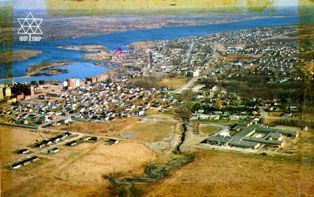
Aerial View of Hawkesbury, Ontario
Description
- Creator
- Unknown, Photographer
- Media Type
- Image
- Item Type
- Postcards
- Description
- A colour postcard depicting the town of Hawkesbury, Ontario in the 1960s.
- Notes
- This postcard was acquired while on a canoe trip taken by Whitby Boy Scouts from Port Perry, ON to Montreal QC, to commemorate the centennial of Canada's confederation. On July 21, 1967, the group of canoers camped in Hawkesbury on the shore of the Ottawa River, before crossing into Quebec.
- Date of Publication
- 21 Jul 1967
- Subject(s)
- Local identifier
- A2017_011_002ZZ
- Collection
- Whitby Online Historic Photographs Collection
- Geographic Coverage
-
-
Ontario, Canada
Latitude: 45.60009 Longitude: -74.61595 -
Ontario, Canada
Latitude: 43.88342 Longitude: -78.93287
-
- Creative Commons licence
 [more details]
- Copyright Statement
- This item is protected by the Canadian Copyright Act and is intended for one-time use only. Uses other than research or private study require the permission of the rightsholder(s). It is your responsibility for obtaining these permissions.
- Copyright Date
- 1967
- Copyright Holder
- Photographer Unknown
- Recommended Citation
- Aerial View of Hawkesbury, Ontario, 1967, Photographer Unknown. Whitby Archives A2017_011_002ZZ
- Reproduction Notes
- Scanned from a colour postcard.
- Contact
- Whitby Public LibraryEmail:archives@whitbylibrary.ca
Website:
Agency street/mail address:405 Dundas Street West, Whitby, Ontario L1N 6A1
For inquires about any newspaper content please contact askreference@whitbylibrary.ca


