South Blair Street, 1956
Description
- Creator
- Charles Mesher, Photographer
- Media Type
- Image
- Item Type
- Negatives
- Description
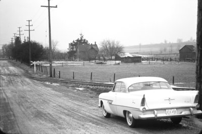
- Black and white negative showing South Blair Street (Dunlop Drive)looking south from the CNR tracks. The house at centre is the Sleep family farm house facing Victoria Street.
- Date of Original
- January 1956
- Dimensions
-
Width: 13 cm
Height: 10 cm
- Subject(s)
- Local identifier
- 16-000-042
- Collection
- Whitby Online Historic Photographs Collection
- Geographic Coverage
-
-
Ontario, Canada
Latitude: 43.8626614764045 Longitude: -78.9238792353821
-
- Donor
- Charles Mesher
- Copyright Statement
- This item is protected by the Canadian Copyright Act and is intended for one-time use only. Uses other than research or private study require the permission of the rightsholder(s). It is your responsibility for obtaining these permissions.
- Recommended Citation
- South Blair Street, 1956, Charles Mesher, Whitby Archives, 16-000-042.
- Reproduction Notes
- Scanned from copy negative.
- Contact
- Whitby Public LibraryEmail:archives@whitbylibrary.ca
Website:
Agency street/mail address:405 Dundas Street West, Whitby, Ontario L1N 6A1
For inquires about any newspaper content please contact askreference@whitbylibrary.ca
