Town Plot of Windsor, 1979
Description
- Creators
- F.P. Rubige, Surveyor
- Totten, Sims, Hubicki Associates Ltd., Cartographer
- Media Type
- Image
- Item Type
- Maps
- Description
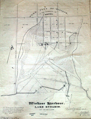
- Photographic image of the Town Plot of Windsor site plan. The plan was created to improve the design of Whitby Harbour. This plan is a 1979 copy of the 1838 original by F.P. Rubige. The 1838 version is based on a 1837 survey by J.J. Dennehy. Plan shows early settlements in Port Whitby, roads, and the design of the harbour.
- Date of Original
- January 1979
- Dimensions
-
Width: 102 cm
Height: 77 cm
- Subject(s)
- Local identifier
- Town Plot of Windsor
- Collection
- Whitby Online Historic Photographs Collection
- Geographic Coverage
-
-
Ontario, Canada
Latitude: 43.85012 Longitude: -78.93287
-
- Copyright Statement
- This item is protected by the Canadian Copyright Act and is intended for one-time use only. Uses other than research or private study require the permission of the rightsholder(s). It is your responsibility for obtaining these permissions.
- Recommended Citation
- Town Plot of Windsor, 1979, Totten, Sims, Hubicki Associates Ltd., Whitby Archives/Whitby Public Library.
- Reproduction Notes
- Photographed by Carl Ferencz
- Contact
- Whitby Public LibraryEmail:archives@whitbylibrary.ca
Website:
Agency street/mail address:405 Dundas Street West, Whitby, Ontario L1N 6A1
For inquires about any newspaper content please contact askreference@whitbylibrary.ca
