Fire Insurance Map 1920 - 1929
Description
- Media Type
- Image
- Item Type
- Maps
- Description
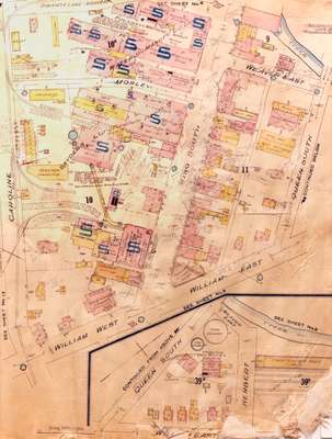
- Fire Insurance map of a section of King Street south to William Street. A sidebar shows William and Regina Streets. Some of the buildings identified are: the Waterloo Manufacturing Company Limited; Dietrich's Garage at King and Morley Streets; Ontario Die Company on the east side of King; Snyder Brothers Upholstering Company; the City Hotel; Alexander House Hotel; First United Church; and the Waterloo Gas works at Queen and Weaver (later Herbert) Streets.
- Notes
- 1920 map updated in 1929.
Queen Street later became Regina Street.
Weaver Street was a small lane approximately where Willis Way is today. On the east side of King Street and south it continued as Weaver and later became Herbert Street.
Park Avenue later became Alexandra Avenue.
Morley Street no longer exists.
See detail photographs for enhanced view of the map.
- Date of Original
- June 1920
- Date Of Event
- June 1920
- Dimensions
-
Width: 51 cm
Height: 30 cm
- Image Dimensions
-
Image Width: 51cm
Image Height: 30cm
- Subject(s)
- Fire insurance maps
Waterloo (Ont.)
Kuntz Brewery (Waterloo, Ont.)
Caroline Street (Waterloo, Ont.)
Queen Street (Waterloo, Ont.)
Regina Street (Waterloo, Ont.)
Snyder Brothers Upholstering Company Limited (Waterloo, Ont.)
Waterloo Manufacturing Company Limited (Waterloo, Ont.)
William Street (Waterloo, Ont.)
City Hotel (Waterloo, Ont.)
First United Church (Waterloo, Ont.)
Alexander House Hotel (Waterloo, Ont.)
Dietrich's Garage (Waterloo, Ont.)
King Street South (Waterloo, Ont.)
Alexandra Avenue (Waterloo, Ont.)
Ontario Die Company Limited (Waterloo, Ont.)
Park Avenue (Waterloo, Ont.)
Weaver Street (Waterloo, Ont.)
Morley Street (Waterloo, Ont.)
Waterloo Gas Works (Waterloo, Ont.)
Herbert Street (Waterloo, Ont.) - Local identifier
- Local History Room, Maps
- Collection
- Fire Insurance Maps
- Language of Item
- English
- Geographic Coverage
-
-
Ontario, Canada
Latitude: 43.462669 Longitude: -80.521717
-
- Copyright Statement
- Copyright has expired according to Canadian law. No restrictions on use.
- Contact
- Waterloo Public LibraryEmail:askus@wpl.ca
Website:
Agency street/mail address:35 Albert Street, Waterloo, Ontario, Canada, N2L 5E2