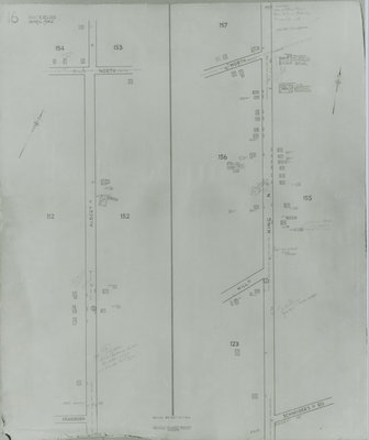
Fire Insurance Map 1942, Map 16
Description
- Media Type
- Image
- Item Type
- Maps
- Description
- Fire Insurance map from 1942 of north central Waterloo in two sections, along Albert Street from Dearborn (later University Avenue) to North (later Columbia) Street, considered the city limits; and along King Street from Schneider's Road (later University Avenue) to North (later Columbia Street). Also shown is Hill Street at King, later Hickory Street. Tru-Craft Millwork Limited and Ornamental Moulding & Carving Company Limited are shown on King Street at North Street.
- Date of Original
- April 1942
- Date Of Event
- April 1942
- Dimensions
-
Width: 20 cm
Height: 25 cm
- Image Dimensions
-
Image Width: 20cm
Image Height: 25cm
- Subject(s)
- Fire insurance maps
Albert Street (Waterloo, Ont.)
King Street North (Waterloo, Ont.)
Dearborn Street (Waterloo, Ont.)
Columbia Street (Waterloo, Ont.)
Schneider's Road (Waterloo, Ont.)
University Avenue (Waterloo, Ont.)
North Street (Waterloo, Ont.)
Hill Street (Waterloo, Ont.)
Hickory Street (Waterloo, Ont.)
Ornamental Moulding & Carving Company Limited (Waterloo, Ont.) - Local identifier
- Local History Room, Maps
- Collection
- Fire Insurance Maps
- Language of Item
- English
- Geographic Coverage
-
-
Ontario, Canada
Latitude: 43.47765 Longitude: -80.529742
-
- Copyright Statement
- Copyright has expired according to Canadian law. No restrictions on use.
- Contact
- Waterloo Public LibraryEmail:askus@wpl.ca
Website:
Agency street/mail address:35 Albert Street, Waterloo, Ontario, Canada, N2L 5E2


