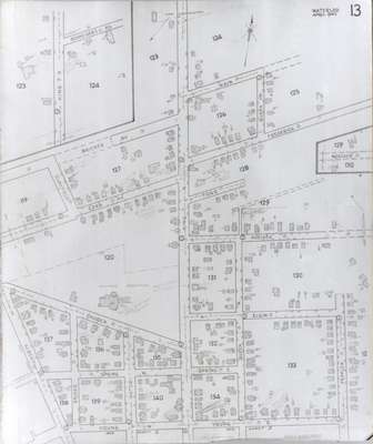
Fire Insurance Map 1942, Map 13
Description
- Media Type
- Image
- Item Type
- Maps
- Description
- Fire Insurance map from 1942 of a northeast section of of Waterloo, Main (later Lodge) Street to the north, Young Street to the south, Albert to the west and Peppler to the east. King Street north to Schneider's Road (later University Avenue) is shown. Some of the buildings visible include: White Rose Service Station (and Inn) at 188 King and Main; Waterloo Cider Mill, King Street south of Schneider's Road; Central School at Church (later Central) Street; Letter & Son Department Store at King and Spring Streets; Hamel & Son Broom Company on Noecker Street; and the New Apostolic Church at King and Noecker Streets.
- Notes
- 1946, 1951 and 1956 show a service station and White Rose Inn and restaurant at 188 King north. Unclear if the service station and inn were jointly owned or two separate businesses.
Main Street became Lodge Street.
Schneider's Road became University Avenue at King Street.
Snider Street became Fountain Street.
Togo Street became James Street.
Frederick Street became Marshall Street.
Dearborn Street became University Avenue at Albert Street. - Date of Original
- April 1942
- Date Of Event
- April 1942
- Dimensions
-
Width: 20 cm
Height: 25 cm
- Image Dimensions
-
Image Width: 20cm
Image Height: 25cm
- Subject(s)
- Fire insurance maps
Young Street (Waterloo, Ont.)
Central School (Waterloo, Ont.)
Dorset Street (Waterloo, Ont.)
Water Street (Waterloo, Ont.)
Letter Family (Waterloo, Ont.)
New Apostolic Church (Waterloo, Ont.)
Church Street (Waterloo, Ont.)
Central Street (Waterloo, Ont.)
Spring Street (Waterloo, Ont.)
Elgin Street (Waterloo, Ont.)
Peppler Street (Waterloo, Ont.)
Snider Street (Waterloo, Ont.)
Fountain Street (Waterloo, Ont.)
Bricker Avenue (Waterloo, Ont.)
Ezra Street (Waterloo, Ont.)
Clayfield Street (Waterloo, Ont.)
Schneider's Road (Waterloo, Ont.)
Main Street (Waterloo, Ont.)
Frederick Street (Waterloo, Ont.)
Togo Street (Waterloo, Ont.)
James Street (Waterloo, Ont.)
Noecker Street (Waterloo, Ont.)
Marshall Street (Waterloo, Ont.)
Lodge Street (Waterloo, Ont.)
Waterloo Cider Mill (Waterloo, Ont.)
Hamel & Son Broom Company (Waterloo, Ont.)
Hamel, I.W.
White Rose Service Station
White Rose Inn (Waterloo, Ont.)
188 King Street north (Waterloo, Ont.) - Local identifier
- Local History Room, Maps
- Collection
- Fire Insurance Maps
- Language of Item
- English
- Geographic Coverage
-
-
Ontario, Canada
Latitude: 43.472263 Longitude: -80.524134
-
- Copyright Statement
- Copyright has expired according to Canadian law. No restrictions on use.
- Contact
- Waterloo Public LibraryEmail:askus@wpl.ca
Website:
Agency street/mail address:35 Albert Street, Waterloo, Ontario, Canada, N2L 5E2


