Fire Insurance Map 1942, Map 10
Description
- Media Type
- Image
- Item Type
- Maps
- Description
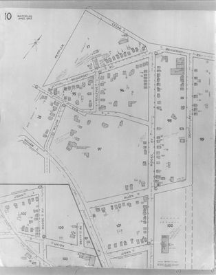
- Fire Insurance map from 1942 of the central east section of the Waterloo business district, Cedar Street (later Bridgeport Road) to the north, John Street to the south, Willow Street to the west and Devitt Avenue to the east. Business and other buildings visible include: Elizabeth Ziegler School on Moore Avenue; Kitchener Spring Company on Bridgeport Road; Waterloo County Orphanage near Willow Street; Ontario Seed Company on Devitt Avenue; Pagel's Hatchery at Cedar (later Bridgeport) Road; and Raitar Transport Company at Devitt Avenue.
- Notes
- Bellevue Avenue later became Tweed Street.
Cedar Street later became Bridgeport Road and was also called Laurel Street east of Peppler Street ca. 1950s.
- Date of Original
- April 1942
- Date Of Event
- April 1942
- Dimensions
-
Width: 20 cm
Height: 25 cm
- Image Dimensions
-
Image Width: 20cm
Image Height: 25cm
- Subject(s)
- Fire insurance maps
Orphanages
Allen Street (Waterloo, Ont.)
John Street (Waterloo, Ont.)
Elizabeth Ziegler School (Waterloo, Ontario)
Union Boulevard (Waterloo, Ont.)
William Street (Waterloo, Ont.)
Bridgeport Road (Waterloo, Ont.)
Ontario Seed Company (Waterloo, Ont.)
Kitchener Spring Company (Waterloo, Ont.)
Cedar Street (Waterloo, Ont.)
Peppler Street (Waterloo, Ont.)
Willow Street (Waterloo, Ont.)
Bellevue Street (Waterloo, Ont.)
Tweed Street (Waterloo, Ont.)
Moore Avenue (Waterloo, Ont.)
Devitt Avenue (Waterloo, Ont.)
Pagel's Hatchery (Waterloo, Ont.)
Raitar Transport Company (Waterloo, Ont.)
Waterloo County Orphanage (Waterloo, Ont.) - Local identifier
- Local History Room, Maps
- Collection
- Fire Insurance Maps
- Language of Item
- English
- Geographic Coverage
-
-
Ontario, Canada
Latitude: 43.466825 Longitude: -80.515093
-
- Copyright Statement
- Copyright has expired according to Canadian law. No restrictions on use.
- Contact
- Waterloo Public LibraryEmail:askus@wpl.ca
Website:
Agency street/mail address:35 Albert Street, Waterloo, Ontario, Canada, N2L 5E2