Fire Insurance Map 1942, Map 8
Description
- Media Type
- Image
- Item Type
- Maps
- Description
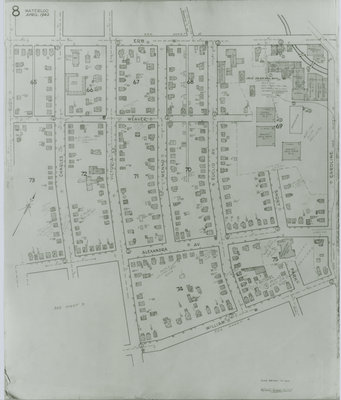
- Fire Insurance map from 1942 of the southwest business and residential district of Waterloo, Erb Street to the north, William Street to the south, Rudy (later Roslin Avenue) Avenue to the west and Caroline Street to the east. The Seagram's Distillery complex is visible as is Alexandra School on Alexandra Avenue and A.H. Foell & Company Transport company on Victoria (later Avondale Avenue) Street.
- Notes
- Rudy Avenue became Roslin (sometimes Roslyn in directories) Avenue.
Victoria Street later became Avondale Avenue.
Charles Street became Dunbar Street.
Weaver Street (sometimes Weber Street in directories) follows the current Dawson Street and ended at the Seagram's Distillery complex. - Date of Original
- April 1942
- Date Of Event
- April 1942
- Dimensions
-
Width: 20 cm
Height: 25 cm
- Image Dimensions
-
Image Width: 20cm
Image Height: 25cm
- Subject(s)
- Fire insurance maps
Joseph E. Seagram and Sons Distillery (Waterloo, Ont.)
Caroline Street (Waterloo, Ont.)
Erb Street (Waterloo, Ont.)
William Street (Waterloo, Ont.)
Alexandra School (Waterloo, Ont.)
Shantz Avenue (Waterloo, Ont.)
Canbar Avenue (Waterloo, Ont.)
Alexandra Avenue (Waterloo, Ont.)
Park Avenue (Waterloo, Ont.)
Short Street (Waterloo, Ont.)
Euclid Avenue (Waterloo, Ont.)
Weaver Street (Waterloo, Ont.)
Victoria Street (Waterloo, Ont.)
Avondale Avenue (Waterloo, Ont.)
Charles Street (Waterloo, Ont.)
Dunbar Avenue (Waterloo, Ont.)
Menno Street (Waterloo, Ont.)
Foell, A. H.
A.H. Foell & Company, Transport (Waterloo, Ont.)
Rudy Street (Waterloo, Ont.)
Roslin Avenue (Waterloo, Ont.)
Dawson Street (Waterloo, Ont.) - Local identifier
- Local History Room, Maps
- Collection
- Fire Insurance Maps
- Language of Item
- English
- Geographic Coverage
-
-
Ontario, Canada
Latitude: 43.460925 Longitude: -80.527146
-
- Copyright Statement
- Copyright has expired according to Canadian law. No restrictions on use.
- Contact
- Waterloo Public LibraryEmail:askus@wpl.ca
Website:
Agency street/mail address:35 Albert Street, Waterloo, Ontario, Canada, N2L 5E2