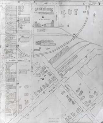
Fire Insurance Map 1942, Map 5
Description
- Media Type
- Image
- Item Type
- Maps
- Description
- Fire Insurance map from 1942 of the southeast business district of Waterloo, Erb Street to the north, George Street to the south, King Street to the west and Willow Street (not visible) to the east. Some of the businesses visible on the map include: L.J. Klopp, Dry Goods; Rennel Drugs; Waterloo Glove Manufacturing Company; W.P. Frank, Jeweller; Liphardt Brothers, Hardware; Modern Bakery, Weichel Hardware; A.B. Learn, Drugs; Oddfellows Lodge; L.R. Detenbeck, Men's Wear; Kitchener Bakery, Hub Billiards and Cigar Store; Roschmann Brothers Button Factory; Henry D. Billiards and Bowling; Clemmer Welding and Repair Shop; Union (City) Hotel; Snider Electrician; Ontario Die Company; J.S. Lackie and Company, Contractors; Wettlaufer Department Store; Miller's Service Station; Alexander Garage; Waterloo Auto Parts; William Hogg Coal Company; M. Wiechel & Son Limited; C.N.R. Station; Welker Industries Limited; Waterloo Gas Works; Waterloo Town Waterworks; Peterson Coal Company; and
Superior Box Company Limited. - Date of Original
- April 1942
- Date Of Event
- April 1942
- Dimensions
-
Width: 20 cm
Height: 25 cm
- Image Dimensions
-
Image Width: 20cm
Image Height: 25cm
- Subject(s)
- Fire insurance maps
Waterloo Glove Manufacturing Company Limited (Waterloo, Ont.)
Erb Street (Waterloo, Ont.)
George Street (Waterloo, Ont.)
Roschman Button Factory (Waterloo, Ont.)
Detenbeck's Men's Clothing Store (Waterloo, Ont.)
Frank's Jewellers (Waterloo, Ont.)
City Hotel (Waterloo, Ont.)
Learn, Arthur B.
Liphardt Hardware Store (Waterloo, Ont.)
Alexander Garage (Waterloo, Ont.)
Clemmer's Welding and Repair Shop (Waterloo, Ont.)
Waterloo Water and Light Commission (Waterloo, Ont.)
King Street South (Waterloo, Ont.)
Frank, W.P.
William Hogg Coal Company (Waterloo, Ont.)
Ontario Die Company Limited (Waterloo, Ont.)
Superior Box Company (Waterloo, Ont.)
Waterloo Gas Works (Waterloo, Ont.)
L.J. Klopp Dry Goods (Waterloo, Ont.)
Klopp, L.J.
Rennel Drugs (Waterloo, Ont.)
Modern Bakery (Waterloo, Ont.)
Weichel Hardware (Waterloo, Ont.)
A.B. Learn Drugs (Waterloo, Ont.)
Oddfellows Lodge (Waterloo, Ont.)
Kitchener Bakery (Waterloo, Ont.)
Hub Billiards and Cigar Store (Waterloo, Ont.)
Union Hotel (Waterloo, Ont.)
Snider Electrician (Waterloo, Ont.)
J.S. Lackie & Company, Contractors (Waterloo, Ont.)
Lackie, J.S.
Wettlaufer Department Store (Waterloo, Ont.)
Miller's Service Station (Waterloo, Ont.)
Wiechel and Son, Limited (Waterloo, Ont.)
Welker Industries Limited
Peterson Coal Company (Waterloo, Ont.) - Local identifier
- Local History Room, Maps
- Collection
- Fire Insurance Maps
- Language of Item
- English
- Geographic Coverage
-
-
Ontario, Canada
Latitude: 43.462687 Longitude: -80.518336
-
- Copyright Statement
- Copyright has expired according to Canadian law. No restrictions on use.
- Contact
- Waterloo Public LibraryEmail:askus@wpl.ca
Website:
Agency street/mail address:35 Albert Street, Waterloo, Ontario, Canada, N2L 5E2


