Fire Insurance Map 1942, Map 4
Description
- Media Type
- Image
- Item Type
- Maps
- Description
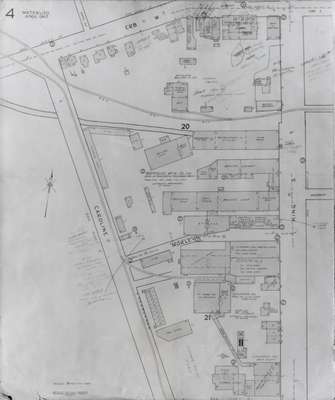
- Fire Insurance map of northeast business district of Waterloo, Young Street to the north, Erb Street to the south, King Street to the west and Peppler Street to the east. Businesses identified on the map include, Harmony Lunch, Garfield Glove Company, Ornamental Moulding and Carving, the Royal Bank, Teerkoot's Garage, Twin City Laundry, Waterloo 5 cent to $1 Store, Waterloo Garage, Waterloo Hotel, Waterloo lawn bowling green, Waterloo Metal Stampings, Waterloo Musical Society Band rooms, Waterloo Mutual Fire Insurance Company offices, Waterloo Shoe Company and the Waterloo Theatre.
- Notes
- 1942 Map.
Duke Street became Dupont Street.
Queen Street became Regina Street.
Cedar Street became Bridgeport Road and was also called Laurel Street east of Peppler Street.
- Date of Original
- April 1942
- Date Of Event
- April 1942
- Dimensions
-
Width: 20 cm
Height: 25 cm
- Image Dimensions
-
Image Width: 20cm
Image Height: 25cm
- Subject(s)
- Fire insurance maps
Queen Street (Waterloo, Ont.)
Regina Street (Waterloo, Ont.)
Young Street (Waterloo, Ont.)
Waterloo Mutual Fire Insurance Company (Waterloo, Ont.)
Waterloo Theatre (Waterloo, Ont.)
Bridgeport Road (Waterloo, Ont.)
Waterloo Hotel (Waterloo, Ont.)
Waterloo Garage (Waterloo, Ont.)
Harmony Lunch (Waterloo, Ont.)
Waterloo Shoe Company (Waterloo, Ont.)
Royal Bank of Canada
Waterloo Musical Society (Waterloo, Ont.)
Waterloo 5 cent to $1 Store (Waterloo, Ont.)
St. John's Lutheram Church (Waterloo, Ont.)
Twin City Laundry (Waterloo, Ont.)
Garfield Glove Company (Waterloo, Ont.)
Waterloo Metal Stampings Limited (Waterloo, Ont.)
Cedar Street (Waterloo, Ont.)
Princess Street (Waterloo, Ont.)
Peppler Street (Waterloo, Ont.)
Duke Street (Waterloo, Ont.)
Dupont Street (Waterloo, Ont.)
Laurel Stree (Waterloo, Ont.)
Teerkott, Frank
Teerkott's Garage (Waterloo, Ont.)
Ornamental Moulding and Carving Company (Waterloo, Ont.)
Waterloo Lawn Bowling (Waterloo, Ont.) - Local identifier
- Local History Room, Maps
- Collection
- Fire Insurance Maps
- Language of Item
- English
- Geographic Coverage
-
-
Ontario, Canada
Latitude: 43.466625 Longitude: -80.52146
-
- Copyright Statement
- Copyright has expired according to Canadian law. No restrictions on use.
- Contact
- Waterloo Public LibraryEmail:askus@wpl.ca
Website:
Agency street/mail address:35 Albert Street, Waterloo, Ontario, Canada, N2L 5E2