Fire Insurance Map 1942, Map 2
Description
- Media Type
- Image
- Item Type
- Maps
- Description
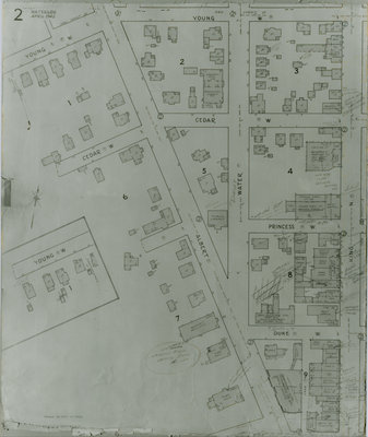
- Fire Insurance map of southwest business district of Waterloo, Young Street to the north, Duke (later Dupont) Street to the south, Albert Street to the west and King Street to the east. Town Hall, Library, Fire Hall and Market building as well as many businesses identified on the map.
- Date of Original
- April 1942
- Date Of Event
- April 1942
- Dimensions
-
Width: 20 cm
Height: 25 cm
- Image Dimensions
-
Image Width: 20cm
Image Height: 25cm
- Subject(s)
- Fire insurance maps
Albert Street (Waterloo, Ont.)
Young Street (Waterloo, Ont.)
Evangelical Church (Waterloo, Ont.)
Waterloo Fire Department (Waterloo, Ont.)
Waterloo City Hall (Waterloo, Ont.)
Dominion Life Assurance Company (Waterloo, Ont.)
Bank of Toronto (Waterloo, Ont.)
Central Billiards (Waterloo, Ont.)
Bridgeport Road (Waterloo, Ont.)
Carnegie Library (Waterloo, Ont.)
John Forsyth Company Limited (Waterloo, Ont.)
Dorset Street (Waterloo, Ont.)
Water Street (Waterloo, Ont.)
Kent Hotel (Waterloo, Ont.)
City Hall (Waterloo, Ont.)
Waterloo Farmers' Market (Waterloo, Ont.)
Bauman Brothers, Tires (Waterloo, Ont.)
Buddell's Garage (Waterloo, Ont.)
Masonic Lodge (Waterloo, Ont.)
Cedar Street (Waterloo, Ont.)
Princess Street (Waterloo, Ont.)
Duke Street (Waterloo, Ont.)
Dupont Street (Waterloo, Ont.)
A & P Food (Waterloo, Ont.) - Local identifier
- Local History Room, Maps
- Collection
- Fire Insurance Maps
- Language of Item
- English
- Geographic Coverage
-
-
Ontario, Canada
Latitude: 43.466547 Longitude: -80.524142
-
- Copyright Statement
- Copyright has expired according to Canadian law. No restrictions on use.
- Contact
- Waterloo Public LibraryEmail:askus@wpl.ca
Website:
Agency street/mail address:35 Albert Street, Waterloo, Ontario, Canada, N2L 5E2