Fire Insurance Map 1908 - 1913, Map 14
Description
- Media Type
- Image
- Item Type
- Maps
- Description
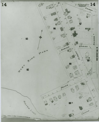
- Fire Insurance map of southwest uptown Waterloo, Church (later Central) Street to the north, Cedar (later Bridgeport) Street to the south, Westside Park (later Waterloo Park) to the west and Snider (later Fountain) Street to the east.
- Notes
- 1908 map updated to 1913.
- Date of Original
- 1913
- Date Of Event
- 1913
- Dimensions
-
Width: 20 cm
Height: 25 cm
- Image Dimensions
-
Image Width: 20cm
Image Height: 25cm
- Subject(s)
- Fire insurance maps
Young Street (Waterloo, Ont.)
Waterloo Park (Waterloo, Ont.)
Bridgeport Road (Waterloo, Ont.)
Westside Park (Waterloo, Ont.)
Church Street (Waterloo, Ont.)
Central Street (Waterloo, Ont.)
Spring Street (Waterloo, Ont.)
Cedar Street (Waterloo, Ont.)
Snider Street (Waterloo, Ont.)
Fountain Street (Waterloo, Ont.) - Local identifier
- Local History Room, Maps
- Collection
- Fire Insurance Maps
- Language of Item
- English
- Geographic Coverage
-
-
Ontario, Canada
Latitude: 43.468106 Longitude: -80.525878
-
- Copyright Statement
- Copyright has expired according to Canadian law. No restrictions on use.
- Contact
- Waterloo Public LibraryEmail:askus@wpl.ca
Website:
Agency street/mail address:35 Albert Street, Waterloo, Ontario, Canada, N2L 5E2