Fire Insurance Map 1908 - 1913, Map 12
Description
- Media Type
- Image
- Item Type
- Maps
- Description
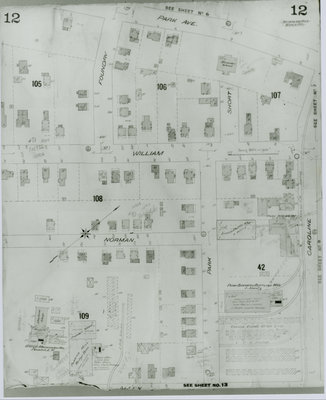
- Fire Insurance map of southwest uptown Waterloo, Park (later Alexandra) Avenue to the north, Allen Street to the south, Caroline Street to the east. Note the Kuntz Park Brewery complex, Canada Furniture Company storage, Reitzel Brothers Planing and Lumber Mill, Bechtel's Limited, manufacturers of bricks and machinery, and Alexandra School.
- Notes
- 1908 map updated to 1913.
- Date of Original
- 1913
- Date Of Event
- 1913
- Dimensions
-
Width: 20 cm
Height: 25 cm
- Image Dimensions
-
Image Width: 20cm
Image Height: 25cm
- Subject(s)
- Fire insurance maps
Kuntz Brewery (Waterloo, Ont.)
Caroline Street (Waterloo, Ont.)
William Street (Waterloo, Ont.)
Canada Furniture Company (Waterloo, Ont.)
Alexandra School (Waterloo, Ont.)
L. Kuntz Park Brewery (Waterloo, Ont.)
Park Avenue (Waterloo, Ont.)
Short Street (Waterloo, Ont.)
Foundry Street (Waterloo, Ont.)
Norman Street (Waterloo, Ont.)
Park Brewery (Waterloo, Ont.)
Reitzel Brothers Planing and Lumber Mill (Waterloo, Ont.)
Bechtel's Limited, Brickmaking and Machinery Manufacturers (Waterloo, Ont.)
Bechtel, Wilson - Local identifier
- Local History Room, Maps
- Collection
- Fire Insurance Maps
- Language of Item
- English
- Geographic Coverage
-
-
Ontario, Canada
Latitude: 43.4589 Longitude: -80.522125
-
- Copyright Statement
- Copyright has expired according to Canadian law. No restrictions on use.
- Contact
- Waterloo Public LibraryEmail:askus@wpl.ca
Website:
Agency street/mail address:35 Albert Street, Waterloo, Ontario, Canada, N2L 5E2