Fire Insurance Map 1908 - 1913, Map 11
Description
- Media Type
- Image
- Item Type
- Maps
- Description
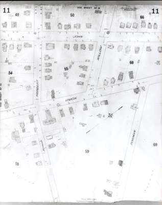
- Fire Insurance map of southeast uptown Waterloo, John Street to the north, Union Street to the south, Herbert Street to the west and Bowman Street to the east. Note the "hop kilns" at Union and Herbert Streets.
- Notes
- 1908 map updated to 1913.
- Date of Original
- 1913
- Date Of Event
- 1913
- Dimensions
-
Width: 20 cm
Height: 25 cm
- Image Dimensions
-
Image Width: 20cm
Image Height: 25cm
- Subject(s)
- Local identifier
- Local History Room, Maps
- Collection
- Fire Insurance Maps
- Language of Item
- English
- Geographic Coverage
-
-
Ontario, Canada
Latitude: 43.461236 Longitude: -80.514486
-
- Copyright Statement
- Copyright has expired according to Canadian law. No restrictions on use.
- Contact
- Waterloo Public LibraryEmail:askus@wpl.ca
Website:
Agency street/mail address:35 Albert Street, Waterloo, Ontario, Canada, N2L 5E2