Fire Insurance Map 1908 - 1913, Map 9
Description
- Media Type
- Image
- Item Type
- Maps
- Description
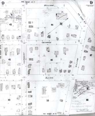
- Fire Insurance map of south uptown Waterloo, William Street to the north, Allen Street to the south, Herbert Street to the west and Willow Street to the east. Businesses visible are the Woellner, Bolduc and Company Furniture Manufacturers and the Waterloo Furniture Company. St. Louis Catholic Church, convent and school are also on the map.
- Notes
- 1908 map updated to 1913.
- Date of Original
- 1913
- Date Of Event
- 1913
- Dimensions
-
Width: 20 cm
Height: 25 cm
- Image Dimensions
-
Image Width: 20cm
Image Height: 25cm
- Subject(s)
- Fire insurance maps
Allen Street (Waterloo, Ont.)
George Street (Waterloo, Ont.)
William Street (Waterloo, Ont.)
St. Louis Catholic Church (Waterloo, Ont.)
Canada Furniture Company (Waterloo, Ont.)
St. Louis Catholic School (Waterloo, Ont.)
Willow Street (Waterloo, Ont.)
Herbert Street (Waterloo, Ont.)
Woeller, Bolduc and Company Furniture Manufacturers (Waterloo, Ont.)
Waterloo Furniture Company Limited (Waterloo, Ont.) - Local identifier
- Local History Room, Maps
- Collection
- Fire Insurance Maps
- Language of Item
- English
- Geographic Coverage
-
-
Ontario, Canada
Latitude: 43.462218 Longitude: -80.517662
-
- Copyright Statement
- Copyright has expired according to Canadian law. No restrictions on use.
- Contact
- Waterloo Public LibraryEmail:askus@wpl.ca
Website:
Agency street/mail address:35 Albert Street, Waterloo, Ontario, Canada, N2L 5E2