Fire Insurance Map, 1908 - 1913, Map 6
Description
- Media Type
- Image
- Item Type
- Maps
- Description
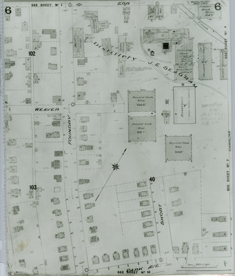
- Fire Insurance map of a section of west uptown Waterloo, focusing on the Joseph E. Seagram and Sons Distillery. Erb Street to the north, Park (later Alexandra) Avenue to the south, Foundry (later Euclid) Street to the west and Caroline Street to the east.
- Notes
- 1908 map updated to 1913.
Weaver Street later became Dawson Street.
See Detail images for closer view of map. - Date of Original
- 1913
- Date Of Event
- 1913
- Dimensions
-
Width: 20
Height: 25
- Image Dimensions
-
Image Width: 20
Image Height: 25
- Subject(s)
- Fire insurance maps
Joseph E. Seagram and Sons Distillery (Waterloo, Ont.)
Caroline Street (Waterloo, Ont.)
Erb Street (Waterloo, Ont.)
William Street (Waterloo, Ont.)
Alexandra Avenue (Waterloo, Ont.)
Park Avenue (Waterloo, Ont.)
Short Street (Waterloo, Ont.)
Foundry Street (Waterloo, Ont.)
Seagram's Distillery (Waterloo, Ont.) - Local identifier
- Local History Room, Maps
- Collection
- Fire Insurance Maps
- Language of Item
- English
- Geographic Coverage
-
-
Ontario, Canada
Latitude: 43.462046 Longitude: -80.525258
-
- Copyright Statement
- Copyright has expired according to Canadian law. No restrictions on use.
- Contact
- Waterloo Public LibraryEmail:askus@wpl.ca
Website:
Agency street/mail address:35 Albert Street, Waterloo, Ontario, Canada, N2L 5E2