Fire Insurance Map, 1908 - 1913, Map 5
Description
- Media Type
- Image
- Item Type
- Maps
- Description
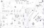
- Fire Insurance map of a section of east uptown Waterloo. Princess Street to the north, William Street to the south, Queen (later Regina) Street to the west and Willow Street to the east. Some businesses visible are Waterloo Garage; a cattle yard; a skating rink; Crown Cigar Box Factory; Waterloo Manufacturing Company; and Spring Tannery. Grand Trunk Railway tracks visible at the bottom.
- Notes
- 1908 map updated to 1913.
Duke Street later became Dupont Street.
Bridgeport Road also called Laurel Street.
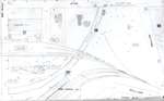
See Detail images for closer view of map. - Date of Original
- 1913
- Date Of Event
- 1913
- Dimensions
-
Width: 20
Height: 25
- Image Dimensions
-
Image Width: 20
Image Height: 25
- Subject(s)
- Fire insurance maps
Erb Street (Waterloo, Ont.)
Queen Street (Waterloo, Ont.)
Regina Street (Waterloo, Ont.)
William Street (Waterloo, Ont.)
Waterloo Manufacturing Company (Waterloo, Ont.)
Bridgeport Road (Waterloo, Ont.)
Waterloo Garage (Waterloo, Ont.)
Princess Street (Waterloo, Ont.)
Peppler Street (Waterloo, Ont.)
Duke Street (Waterloo, Ont.)
Dupont Street (Waterloo, Ont.)
Willow Street (Waterloo, Ont.)
Skating rink (Waterloo, Ont.)
Crown Cigar Box Factory (Waterloo, Ont.)
Spring Tannery (Waterloo, Ont.) - Local identifier
- Local History Room, Maps
- Collection
- Fire Insurance Maps
- Language of Item
- English
- Geographic Coverage
-
-
Ontario, Canada
Latitude: 43.465753 Longitude: -80.518777
-
- Copyright Statement
- Copyright has expired according to Canadian law. No restrictions on use.
- Contact
- Waterloo Public LibraryEmail:askus@wpl.ca
Website:
Agency street/mail address:35 Albert Street, Waterloo, Ontario, Canada, N2L 5E2