Fire Insurance Map, 1908 - 1913, Map 3
Description
- Media Type
- Image
- Item Type
- Maps
- Description
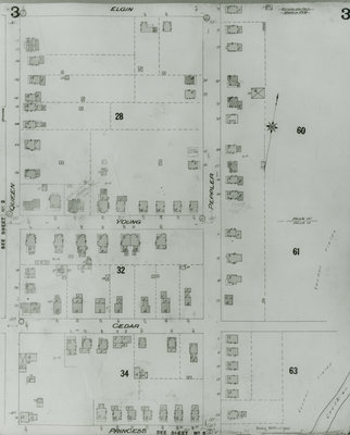
- Fire Insurance map of uptown Waterloo north, Elgin Street to the north, Princess Street to the south, Queen (later Regina) Street to the west and Peppler Street to the east.
- Notes
- 1908 map updated to 1913.
Cedar Street later became Bridgeport Road and was also called Laurel Street east of Peppler.
See Detail images for closer view of map. - Date of Original
- 1913
- Date Of Event
- 1913
- Dimensions
-
Width: 20 cm
Height: 25 cm
- Image Dimensions
-
Image Width: 20cm
Image Height: 25cm
- Subject(s)
- Local identifier
- Local History Room Maps
- Collection
- Fire Insurance Maps
- Language of Item
- English
- Geographic Coverage
-
-
Ontario, Canada
Latitude: 43.468899 Longitude: -80.520902
-
- Copyright Statement
- Copyright has expired according to Canadian law. No restrictions on use.
- Contact
- Waterloo Public LibraryEmail:askus@wpl.ca
Website:
Agency street/mail address:35 Albert Street, Waterloo, Ontario, Canada, N2L 5E2