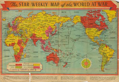
The Star Weekly Map of the World at War, 1944
Description
- Creator
- The Star Weekly Newspaper, Photographer
- Media Type
- Image
- Text
- Item Type
- Maps
- Description
- This is a map that was published in The Star Weekly, Toronto newspaper. The map was published on December 23, 1944 and shows the land that was occupied by the Allies and Axis powers, as well as the land that belonged to the British Empire and neutral countries. The map also shows air distances, supply routes, main railways and naval battles. Note the orientation of the map and the text at the bottom.
On the reverse of the map is a Christmas message from the House of Seagram. - Publisher
- The Star Weekly
- Place of Publication
- Toronto, Ontario
- Date of Original
- December 23, 1944
- Dimensions
-
Width: 54 cm
Height: 37.5 cm
- Subject(s)
- Corporate Name(s)
- Seagram's Distillery
- Local identifier
- Box MM
- Language of Item
- English
- Donor
- Shirley Dueck
- Copyright Statement
- To obtain a copy of this item and for terms of use please contact the Waterloo Public Library.
- Contact
- Waterloo Public LibraryEmail:askus@wpl.ca
Website:
Agency street/mail address:35 Albert Street, Waterloo, Ontario, Canada, N2L 5E2


