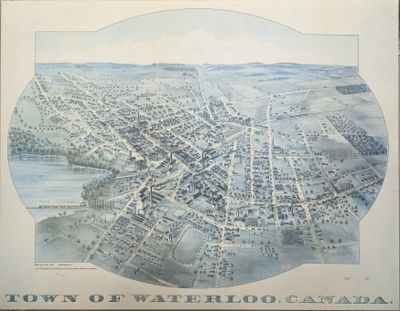
1891 Town of Waterloo Map
Description
- Media Type
- Image
- Item Types
- Photographs
- Maps
- Description
- Aerial drawing of the Town of Waterloo.
- Notes
- The printed date in the right hand corner of the second version of the map is incorrect. The map can be dated to ca. 1891 based on other copies and the presence of St. Louis Roman Catholic Church on Allen St.
- Date of Original
- [ca.1891]
- Dimensions
-
Width: 18 cm
Height: 13 cm
- Image Dimensions
-
Image Width: 18cm
Image Height: 13cm
- Subject(s)
- Maps
Albert Street (Waterloo, Ont.)
Allen Street (Waterloo, Ont.)
Caroline Street (Waterloo, Ont.)
Erb Street (Waterloo, Ont.)
George Street (Waterloo, Ont.)
John Street (Waterloo, Ont.)
Queen Street (Waterloo, Ont.)
William Street (Waterloo, Ont.)
Young Street (Waterloo, Ont.)
King Street (Waterloo, Ont.)
Waterloo Map
Mary Street (Waterloo, Ont.)
Water Street (Waterloo, Ont.)
Church Street (Waterloo, Ont.)
Spring Street (Waterloo, Ont.)
Cedar Street (Waterloo, Ont.)
Elgin Street (Waterloo, Ont.)
Duke Street (Waterloo, Ont.)
Willow Street (Waterloo, Ont.)
Foundry Street (Waterloo, Ont.)
Weaver Street (Waterloo, Ont.)
Herbert Street (Waterloo, Ont.)
Snider Street (Waterloo, Ont.)
Menno Street (Waterloo, Ont.)
Frederick Street (Waterloo, Ont.)
Pine street (Kitchener, Ont.)
Park Street (Waterloo, Ont.)
Union Street (Waterloo, Ont.) - Local identifier
- A-3-6; A-3-15; A-3-16; J-13-1
- Language of Item
- English
- Geographic Coverage
-
-
Ontario, Canada
Latitude: 43.465187 Longitude: -80.522372
-
- Copyright Statement
- Copyright has expired according to Canadian law. No restrictions on use.
- Contact
- Waterloo Public LibraryEmail:askus@wpl.ca
Website:
Agency street/mail address:35 Albert Street, Waterloo, Ontario, Canada, N2L 5E2