Portions of 1891 Map of Waterloo
Description
- Media Type
- Image
- Item Type
- Slides
- Description
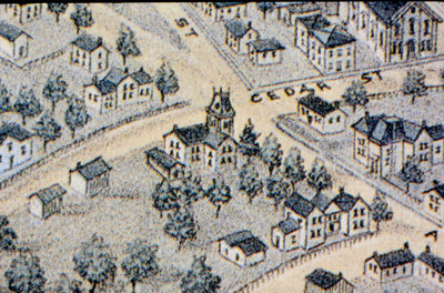
- A portion of an 1891 bird's-eye-view map of Waterloo showing the intersection of Cedar (later Bridgeport) and Albert streets. The second image of the map shows the Union Street (vertical) and Herbert Street (horizontal) intersection.
- Notes
- The entire map located in Ellis Little Local History Room at the Waterloo Public Library.
- Date of Original
- 1891
- Dimensions
-
Width: 5
Height: 5
- Image Dimensions
-
Image Width: 3.5
Image Height: 2.3
- Subject(s)
- Local identifier
- Local History Slide Collection
- Language of Item
- English
- Geographic Coverage
-
-
Latitude: 43.459123 Longitude: -80.508418
-
- Copyright Statement
- Copyright status unknown. Responsibility for determining the copyright status and any use rests exclusively with the user.
- Contact
- Waterloo Public LibraryEmail:askus@wpl.ca
Website:
Agency street/mail address:35 Albert Street, Waterloo, Ontario, Canada, N2L 5E2