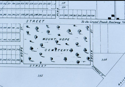
Map of Waterloo 1855 showing Mount Hope Cemetery
Description
- Media Type
- Image
- Item Type
- Slides
- Description
- A portion of a "Map of the Village of Waterloo and Part of the Town of Berlin Laid out for John Hoffman Esquire by M.C. Schofield". This portion shows Mount Hope Cemetery which straddles the border between Waterloo and Kitchener.
- Notes
- Entire map located in Waterloo Public Library local history room.
- Date of Original
- 1855
- Subject(s)
- Local identifier
- Local History Slide Collection
- Language of Item
- English
- Geographic Coverage
-
-
Latitude: 43.459123 Longitude: -80.508418
-
- Copyright Statement
- Copyright has expired according to Canadian law. No restrictions on use.
- Contact
- Waterloo Public LibraryEmail:askus@wpl.ca
Website:
Agency street/mail address:35 Albert Street, Waterloo, Ontario, Canada, N2L 5E2


