Waterloo Township list with names of early property owners
Description
- Creator
- Ellis Little, Artist
- Media Type
- Image
- Item Type
- Drawings
- Description
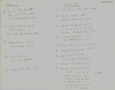
- A list of "Lower Block" property owners for Concessions 1-3. This map shows the area of Hespeler, bordered by Puslinch to the east and township of North Dumfries to the south; first settled by Abraham Clemens, now part of Cambridge.
- Notes
- These maps are hand drawn by Ellis Little and outline over 90000 acres of land granted (Block 2, Waterloo Township) to the Six Nations Indians by the British Crown in 1784 and sold in 1798 to Richard Beasley, James Wilson and John Baptist Rousseaux who looked to resell the land in small parcels. German Company tract became Waterloo township.
The first of the Pennsylvanian Mennonites to own land in the Hespeler area was Abraham Clemens who arrived in 1809 having purchased 515 acres from Beasley.
See also: "Historical Atlas of Waterloo & Wellington Counties, 1877-1881", pg. 23, map of Waterloo Township; and City of Cambridge website. Waterloo Historical Society, 1965 for map of German Company tract/Waterloo township lots with 1805 owners. - Dimensions
-
Width: 20 cm
Height: 25 cm
- Image Dimensions
-
Image Width: 20cm
Image Height: 25cm
- Subject(s)
- German Company Tract (Waterloo, Ont.)
Scollick, William
Stauffer, Abraham
Bricker, John
Pannebaker, Cornelius
Gingrich, Abraham
Clemens, George
Meyers, Jacob
Ziegler, Solomon
Lamb, Henry
Clemmer, Henry
Gingerich, David
Witmer, Abraham
Baer, Martin
Groh, John
Stauffer, Samuel
Clemens, Abraham
Deweiler, Rudolf
Wanner, Henry
Masters, Isaac
Stricker, Arnold
Coplin, William
Moore, Henry
Cooke, Rob
Rickwine, Chris
Walcott, John
Huntzberger, Martin
Bearinger, David
Bearinger, Joseph
Groh, Jacob
Bechtel, Samuel
Bretz, Jacob
Witmer, Peter
Strome, David
Ellis, William
Strome, Jacob - Local identifier
- ELP 50 38
- Collection
- Ellis Little Papers
- Language of Item
- English
- Geographic Coverage
-
-
Latitude: 43.42051 Longitude: -80.323727
-
- Copyright Statement
- Uses other than research or private study require the permission of the rightsholder(s). Responsibility for obtaining permissions and for any use rests exclusively with the user.
- Contact
- Waterloo Public LibraryEmail:askus@wpl.ca
Website:
Agency street/mail address:35 Albert Street, Waterloo, Ontario, Canada, N2L 5E2