Waterloo Township map with names of early property owners
Description
- Creator
- Ellis Little, Artist
- Media Type
- Image
- Item Type
- Drawings
- Description
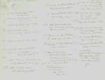
- Hand drawn maps of early Waterloo township with the names of property owners and approximate dates of ownership.
This map shows the area of Hespeler, first settled by Abraham Clemens, now part of Cambridge. - Notes
- These maps are hand drawn by Ellis Little and outline over 90000 acres of land granted (Block 2, Waterloo Township) to the Six Nations Indians by the British Crown in 1784 and sold in 1798 to Richard Beasley, James Wilson and John Baptist Rousseaux who looked to resell the land in small parcels. Germany Company tract became Waterloo township.
The first of the Pennsylvanian Mennonites to own land in the Hespeler area was Abraham Clemens who arrived in 1809 having purchased 515 acres from Beasley.
See also: "Historical Atlas of Waterloo & Wellington Counties, 1877-1881"; and City of Cambridge website. See Waterloo Historical Society journal 1965 for 1805 German Company tract/Waterloo township lot map with owners' names. - Dimensions
-
Width: 20 cm
Height: 25 cm
- Image Dimensions
-
Image Width: 20cm
Image Height: 25cm
- Subject(s)
- German Company Tract (Waterloo, Ont.)
Erb, John
Scollick, William
Erb, Jacob
Bamberger, P.
Bechtel, Jacob
Rosenberger, Benjamin
Snider, Christian
Betzner, Samuel Sr.
Cornell, Daniel
Bricker, John
Shantz, Christian
Beasley, Richard
Sherk, Joseph
Crouse, John
Snider, David
Livergood, John
Reichart, Christian
Schlieter, Daniel
Shupe, John
Bamberger, John
Riechert, Christian
Bomberger, Peter
Smith, Samuel
Schneider, Christian
Schneider, D.
Miller, C.
Hilborn, Joseph
Hilborn, James
Bechtel, William
Cressman, S.
Hilborn, S.
Sherk, John
Cornell, J.
Springer, B.
Wheeler, Garret
Gingrich, John
Clemens, Jesse
McMahon, James
Pennebaker, Cornelius
Pennebaker, Henry
Gingrich, Abraham
Clemens, George
Meyers, Jacob
Lamb, Henry
Gingerich, David
Witmer, Abraham
Baer, Martin
Groh, John
Stauffer, Samuel
Clemens, Abraham
Wanner, Henry
Stricker, Arnold
Moore, Henry
Bearinger, David
Bearinger, Joseph
Groh, Jacob
Bechtel, Samuel
Witmer, Peter
Ellis, William
Detweiler, Rudolph
Walcot, John
Stromer, David
Stromer, Christian - Local identifier
- ELP 50 37
- Collection
- Ellis Little Papers
- Language of Item
- English
- Geographic Coverage
-
-
Latitude: 43.43561 Longitude: -80.317655
-
- Copyright Statement
- Uses other than research or private study require the permission of the rightsholder(s). Responsibility for obtaining permissions and for any use rests exclusively with the user.
- Contact
- Waterloo Public LibraryEmail:askus@wpl.ca
Website:
Agency street/mail address:35 Albert Street, Waterloo, Ontario, Canada, N2L 5E2