Map of Glen Bernard Camp, circa 1985
Description
- Creator
- Chrismar Mapping Services, Cartographer
- Media Type
- Text
- Item Type
- Maps
- Description
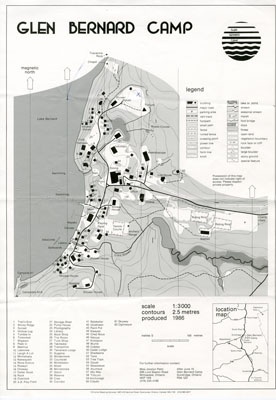
- Black and white map of Glen Bernard Camp. The camp is near Sundridge Ontario. The map is on the top half of the image. In the lower half of the image is a legend and scale.
- Publisher
- Chrismar Mapping Services
- Place of Publication
- Toronto, ON
- Date of Original
- circa 1985
- Date Of Event
- circa 1985
- Map Scale
- 1:3 000
- Subject(s)
- Local identifier
- Edgar Family File
- Geographic Coverage
-
-
Ontario, Canada
Latitude: 45.7668 Longitude: -79.39964
-
- Creative Commons licence
 [more details]
- Copyright Statement
- Protected by copyright: Uses other than research or private study require the permission of the rightsholder(s). Responsibility for obtaining permissions and for any use rests exclusively with the user.
- Copyright Date
- 1985
- Terms of Use
- For Educational Purposes
- Reproduction Notes
- For Educational Purposes
- Contact
- Sundridge - Strong Union PLEmail:sundridgelibrary@gmail.com
Website:
Agency street/mail address:Box 429, 110 Main St.
Sundridge, ON P0A 1Z0