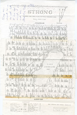
Map of Strong Township, 1942
Description
- Creator
- Department of Lands and Forests, Parry Sound District, Author
- Media Type
- Image
- Text
- Item Type
- Maps
- Description
- A map of Strong Township, produced in 1942. It shows the division of property in Strong Township and names of the land owners. Lake Bernard is near the center of the township. There is a legend at the bottom of the map.
Machar Township borders on the north, Chapman on the west, Joly on the east, and Armour in the south. The map was printed in black ink on white paper. - Inscriptions
- The Legend includes: Trunk road, Secondary Road, Local road, winter Road, Portage or Trail, Buildings, Lookout Tower, Telephone Line, Sawmill, Dam, Bridge, Transmission Line, Lumber Camp, Lookout Point, Tree Plantation, Swamp and Open Flat.
- Publisher
- Department of Lands and Forests, Parry Sound District
- Place of Publication
- Toronto
- Date of Original
- 1942
- Dimensions
-
Width: 11 in
Height: 17 in
- Subject(s)
- Language of Item
- English
- Geographic Coverage
-
-
Ontario, Canada
Latitude: 45.7501 Longitude: -79.41634
-
- Creative Commons licence
 [more details]
- Copyright Statement
- Protected by copyright: Uses other than research or private study require the permission of the rightsholder(s). Responsibility for obtaining permissions and for any use rests exclusively with the user.
- Copyright Date
- 1942
- Contact
- Sundridge - Strong Union PLEmail:sundridgelibrary@gmail.com
Website:
Agency street/mail address:Box 429, 110 Main St.
Sundridge, ON P0A 1Z0