The Flats After Flooding
Description
- Media Type
- Image
- Item Type
- Photographs
- Description
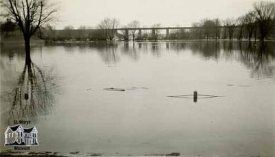
- This image shows the Flats (Milt Dunnell Field) flooded with water from the Thames River. In the background, towards the north, the Sarnia Bridge can be seen crossing the river. The Sarnia Bridge served the Grand Trunk Railway for 130 years. In 1857, the Grand Trunk Railway announced that they would be opening two lines to St. Marys: one from Sarnia and one from London. The first train crossed the Sarnia Bridge in 1859. The London Bridge still serves the Grand Trunk Railway today, but the last train crossed the Sarnia line in 1989. In 1996, a committee was formed to redevelop the railway line through St. Marys into a walking trail. Since its inception, the Sarnia Bridge has been a landmark and image for tourists, photographers, and artists.
- Subject(s)
- Local identifier
- andrews012
- Collection
- St. Marys Museum photo collection
- Language of Item
- English
- Geographic Coverage
-
-
Ontario, Canada
Latitude: 43.2611544134544 Longitude: -81.1451421270752
-
- Copyright Statement
- Copyright status unknown. Responsibility for determining the copyright status and any use rests exclusively with the user.
- Recommended Citation
- "The Flats After Flooding." St. Marys Museum, andrews012.
- Location of Original
- St. Marys Museum Archives
- Terms of Use
- Reproduction of digital objects is restricted to fair use for personal study or research; any other use must be done with permission of copyright holder.
- Reproduction Notes
- This image is a watermarked low resolution reproduction.
High resolution images are available at the St. Marys Museum for a fee.
- Contact
- St. Marys MuseumEmail:museum@town.stmarys.on.ca
Website:
Agency street/mail address:177 Church Street South,
P.O. Box 998,
St. Marys, Ontario.
N4X 1B6


