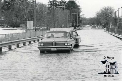
Flooding Near the Quarry, March 1977
Description
- Creator
- Paul Bedford, Photographer
- Media Type
- Image
- Item Type
- Photographs
- Description
- This is a photograph of Water Street by the Quarry during a flood in March 1977. You can see that the road is blocked off, but there are two cars driving through the deep water. One of them appears to have its trunk open.
In the distance, you can see that the posted speed limit is 25. This would have been in miles per hour, but Ontario's highways changed to the metric system in September later that year. - Notes
- Condition: good.
- Date of Publication
- Mar 1977
- Dimensions
-
Width: 18.6 cm
Height: 12.7 cm
- Image Dimensions
-
Image Width: 17.4cm
Image Height: 11.7cm
- Subject(s)
- Local identifier
- macke091
- Collection
- Macke Collection
- Language of Item
- English
- Geographic Coverage
-
-
Ontario, Canada
Latitude: 43.2500808379946 Longitude: -81.1483208837934
-
- Donor
- Marlene Macke
- Copyright Statement
- Copyright status unknown. Responsibility for determining the copyright status and any use rests exclusively with the user.
- Recommended Citation
- Macke Collection. "Flooding Near the Quarry, March 1977" St. Marys Museum, macke091.
- Location of Original
- R. Lorne Eedy Archives
- Terms of Use
- Reproduction of digital objects is restricted to fair use for personal study or research; any other use must be done with permission of copyright holder.
- Reproduction Notes
- This image is a watermarked low resolution reproduction.
High resolution images are available at the St. Marys Museum for a fee. - Contact
- St. Marys MuseumEmail:museum@town.stmarys.on.ca
Website:
Agency street/mail address:177 Church Street South,
P.O. Box 998,
St. Marys, Ontario.
N4X 1B6


