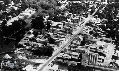
Aerial View of St. Marys, Ont.
Description
- Media Type
- Image
- Description
- This image is one in a series of postcards from the Reg Near collection. It is an aerial view of downtown St. Marys looking northeast, with Town Hall and the flour mill in full view. On the left side, Trout Creek is visible, along with the three bridges that cross it.
- Notes
- Condition: Excellent - Some wear on all four corners
- Inscriptions
- "Aerial View of St. Marys, ONT"
- Dimensions
-
Width: 13.9 cm
Height: 8.9 cm
- Image Dimensions
-
Image Width: 13.1cm
Image Height: 7.9cm
- Subject(s)
- Personal Name(s)
- Near, Reg.
- Local identifier
- RN6_81
- Collection
- Reg Near Postcards
- Language of Item
- English
- Geographic Coverage
-
-
Ontario, Canada
Latitude: 43.25009 Longitude: -81.13304
-
- Donor
- Reg Near
- Copyright Statement
- Copyright status unknown. Responsibility for determining the copyright status and any use rests exclusively with the user.
- Recommended Citation
- "Aerial View of St. Marys, Ont." St. Marys Museum, RN6_81.
- Location of Original
- R. Lorne Eedy Archives
- Terms of Use
- Reproduction of digital objects is restricted to fair use for personal research or study; any other use must be done with permission of copyright holder. As per request of donors on behalf of Reg Near, the original collection is to remain in the St. Marys Museum building and kept in the archival vault at all times. Retrieval from the vault is allowed for viewing under supervision of St. Marys Museum staff only.
- Reproduction Notes
- This image is a watermarked low resolution reproduction. High resolution images are available at the St. Marys Museum for a fee.
- Contact
- St. Marys MuseumEmail:museum@town.stmarys.on.ca
Website:
Agency street/mail address:177 Church Street South,
P.O. Box 998,
St. Marys, Ontario.
N4X 1B6


